Greetings readers, Meteorologist Christopher Cawley here with your CCN Weather Update for Monday January 6, 2025.
We’ll have some rather active weather during the day today. A warm front has lifted north over the area. Mostly cloudy skies should dominate through the morning hours, although we may see some breaks of sunshine as well. It’s likely to become progressively more breezy as we move through the morning hours, and modeling suggests wind gusts in the 30-40 mph range from late this morning through late this afternoon. A renegade shower or two may pop up, but on the whole, we should remain dry through about noon.
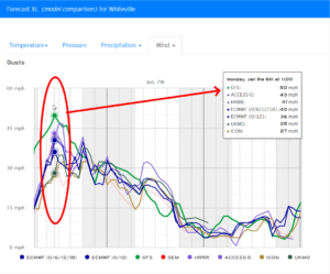
The wind graph here shows the various model wind gust peaks around 11 AM generally from 27-50 mph (according to the modeling anyway).
A period of rain is likely to occur just ahead of a strong cold front, which will cross the county this afternoon. The latest high-res future radars show this area impacting ColCo between noon and 3 PM — the attached chart is for around 1 PM. The high-res guidance has been remarkably consistent with this area of rain so I have very little reason to dispute it.
While we will likely have some gusty winds at times, no severe weather is expected with this line or the frontal passage.
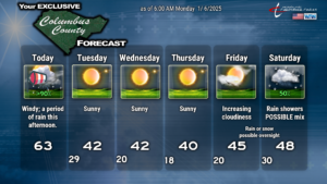
It’ll be warm today ahead of the front. The strong southerly flow will push our temps into the 60s ahead of this front.
Don’t get to used to it.
Like I said, the front crosses the county later this afternoon, or perhaps around suppertime depending on which model you want to choose. The very latest high-res guidance shows an area of precipitation wrapping in behind the front this evening, through about midnight. The vast majority of this precipitation goes off to our north. Now… this is important… because of the timing between this precipitation area and the falling temps. Guidance suggests any snow stays well off to the north, north of a line from Raleigh to Elizabeth City. BUT… if temps can fall quickly enough and enough moisture hangs around, there may be a few sleet pellets or wet snowflakes around here toward midnight. The modeling doesn’t suggest this, and perhaps this might be a little bit of wishcasting here, but there is the “one percent” potential for some moisture to linger.
Either way, skies quickly clear after midnight and temperatures continue to tumble. Winds will stay elevated through at least the evening hours, gradually diminishing overnight.
Tuesday morning bus-stop temps should be in the upper 20s to around 30 with clear skies.
Cold high pressure of Arctic origin takes hold of our weather Tuesday through Friday. Highs will generally be in the lower 40s on Tuesday and Wednesday. A secondary little boundary moves through on Wednesday night, with a reinforcing shot of Arctic air, and our highs will be lucky to reach 40 on Thursday.
Then all eyes turn to next weekend’s weather system.
Nearly certain: A storm system comes together in the northern Gulf of Mexico by Friday.
Not certain at all: Anything that happens after that, including storm track and precipitation types.
The storm track will have HUGE ramifications on whether or not we get any of the white stuff here in southeast NC. A track shift as little as 50-100 miles can mean the difference between a snowfall, an ice storm, or a cold rain.
The model ensembles are pointing in the direction of at least SOME snowfall or frozen precip, but not much … and whatever we get transitions to cold rain on Saturday.
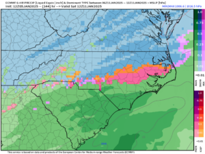
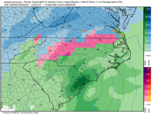
Attached here are the very latest GFS and European model solutions for 7 AM Saturday. If you’re rooting for snow, those aren’t pretty charts. Note — these are going to change about 284 times between the time you read this and when the actual event occurs.
But the ensembles have some disagreement on the track of this system and this is understandable since we’re still 6 days out.
For what it’s worth, NWS discussions also highlight the fact that we’re too far out in time to make any solid determination on storm track. They’re simply going with “rain or snow” for Friday night, and “showers” on Saturday.
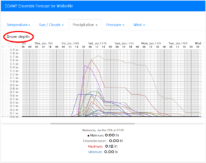
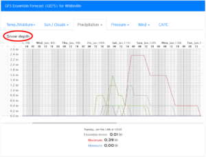
Below are two charts showing the GFS ensembles and the European ensembles SNOW DEPTH beginning on Friday. Both sets imply generally an inch or two of snowfall here, mainly during the overnight Friday night into Saturday. Remember… these are just models. NOT a forecast.
For what it’s worth, the latest Euro ensemble snow matrix chart has 24 out of the 50 members with snowfall here. Nothing more than about an inch or two, but … it’s something.
It’s just too early to call right now. I would say that by Wednesday I will have a much better grasp on what we can expect, if anything.
After THAT… more cold air appears to be in place as the NAO remains solidly negative through the 20th on Euro and GFS ensembles. Euro entertains another potential coastal storm on the 17th-18th, as does the GFS, but both suggest rain. Too far out in time to even give any consideration.
Ok folks, that’ll do it for today’s update. Thank you for reading and, as always, take care.
–Meteorologist Christopher Cawley

