Hello everyone, Meteorologist Christopher Cawley here with your CCN News Weather Update for Tuesday January 7, 2025.
High pressure of Arctic origin is taking control of our weather and will dominate into Friday.
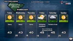
COLD TEMPERATURES: Early morning school-bus-stop temperatures are likely to be in the upper teens to lower 20s on Wednesday, Thursday, and Friday mornings. Wind chill values will be in the 10- to 15-degree range. Please make sure your kids are dressed appropriately at the bus stop.
At this point it would take a miracle for Columbus County to get any snowfall Friday night or into Saturday.
Arctic high pressure will be in place on Friday. At the same time a low will be developing over the northern Gulf of Mexico. There will be some interaction between that and a disturbance diving across the Plains. Now… timing and location. I think the models are too fast bringing precipitation into the area Friday night because there is likely to be VERY dry air in place. The radar might look “active” later Friday evening and Friday night, but it will be a case of precipitation falling from the cloud, hitting that dry air, and evaporating before hitting the ground (a phenomenon called “virga”).
The atmospheric profiles are not conducive for snowfall. As the low heads across northern Florida and into the coastal waters, “warm” (relatively speaking), moist air will infiltrate the middle layers of the atmosphere.
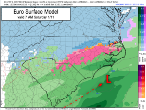
Here are where the questions arise regarding the storm track. The European shows our storm system hugging the coast. In this case, the atmosphere will warm to above-freezing temps at all layers relatively quickly. During this “warm-up” phase, a period of light freezing rain is possible during the overnight hours Friday night… before transitioning to all rain early on Saturday. If the storm stays 50-100 miles offshore (as is implied by some of the ensemble members), there is at least a few hours where some light freezing rain or light sleet will hang on a bit longer early Saturday before a changeover to rain.
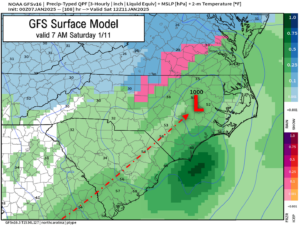
Tbe GFS takes the low and lifts it across eastern South Carolina and then essentially up the I-95 corridor in NC. This points to an all-rain scenario for the entire event.
In both the Euro and GFS scenarios, the precipitation pulls away before colder air filters back in, so very little (if any) chance for snow on the back side of the departing system.
As far as precipitation amounts, model blends are pointing toward a storm total precip of between three-quarters and one inch Friday through Saturday. This will depend quite heavily on the eventual storm track. If the track is farther offshore, we’ll have less precip impacts. If the storm track is along the shore or overland (as per the GFS), then expect closer to an inch of rainfall.
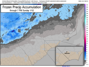
The model blends do paint a picture of a trace to 0.2″ frozen precip across the northern portions of the county, north of 74/76, into Robeson and Bladen counties. I’ll watch this trend but for right now I don’t think it’s going to be anything to lose sleep about. Bridges and secondary roads may be a little slick early Saturday morning if this pans out.
Saturday will feature periods of rain, likely tapering off during the afternoon. It will be breezy and cold … a perfect day to stay inside and play a board game with your family. After the storm moves out of here Saturday night, we continue with the cold, dry weather beyond that point.
That’ll do it for today’s report.
On a personal note, as was so stunningly illustrated to me yesterday, life is short, fragile, and fleeting. All of us at CCN, as well as numerous friends, family members, and neighbors, mourn the loss of our dear friend and colleague, Misty Cribb. If you’re the praying type, please lift her sweet little girl Kyla up, as she sustained significant injuries. Cherish your loved ones, cherish your time with them. At the end of the day, that’s the only thing that really matters in this world.
–Chris


