Greetings friends and neighbors, welcome to the Wednesday edition of the CCN Weather Update!
Not a whole lot to talk about in the short-term, through about noon on Friday, as dry high pressure stays in FIRM control of things.
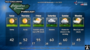
Cold day on tap for today… we’ll have highs generally in the lower 40s. With clear skies and calm winds tonight, and a bone dry air mass in place, we’re going down to the upper teens/lower 20s.
Speaking of the excessively dry air, a high fire danger is in place across all of NC. Please use extreme caution if you’re doing any burning.
Temperatures rebound on Thursday as the Arctic high slips offshore… we’ll push back into the lower 50s… and into the mid 50s on Friday (which is where we SHOULD be this time of year).
Our next system then approaches this weekend. We will be sitting in between middle-atmospheric “ridging” and a cold front. Yesterday the modeling was just a hot mess with regards to timing and such and I said I would just go with “gut instinct and experience,” and predict a cold front passage on Saturday.
Well the latest guidance is pretty much on par with that assessment. Chris 1, Models 0.
Anyway, shower chances start to ramp up late Friday night or early Saturday morning. The front looks like it’ll get kind of “slung out” in a northeast-to-southwest orientation, and therefore it will likely take it’s sweet time pushing all the way through. That might not happen until sometime on Sunday. In the meantime, showers are likely on Saturday, a little bit less likely Saturday night, and then probably ending around lunchtime on Sunday.
As for total rainfall from this, it doesn’t appear that it’s going to be an awful lot. Blending all the modeling together tells me generally around three-quarters of an inch of rainfall for the weekend event, and judging by the dynamics and again, past experience, that sounds about right.
“Ok Chris, that’s great, what about the snow next week? TikTok says we’re going to get a foot of snow.”
It really IS starting to look like a wintry scenario may be unfolding. It looks even better than the storm we had last week.
To get a good snow event here, we need cold, and we need moisture. Storm track and timing also matter.
Cold … no problem. It’s going to be IMPRESSIVELY cold. How cold? How about highs in the lower 30s with lows deep into the teens. Even at the beaches. That occurs Tuesday through Thursday.
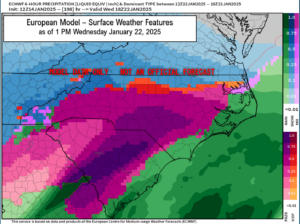
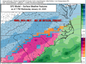
Moisture … hmm. The individual deterministic model runs change every 6 hours. But ensembles are starting to come together with some interesting solutions. The deterministic models, as of the latest available, point to ice (possibly a lot of it) to rain. 12 hours ago, the Euro had absolutely nothing while the GFS bombed us with a snowstorm. That’s why we can’t put much weight in the single-image snapshot that the people are sharing all over social media.
That Euro would illustrate a truly historic, catastrophic ice storm. Fortunately this model will change a multitude of times between now and next week.
Ensemble profiles is where it’s at… and the ensembles are looking mighty interesting if you want to see snow here.
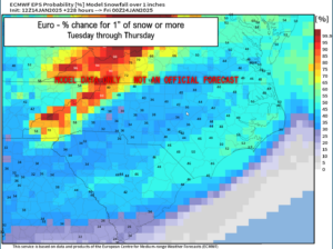
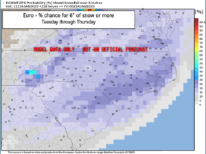
The European ensembles, blended together, give us a 46% chance of seeing at least 1 inch of snow next week… and a 20% chance of seeing at least 6 inches of snow next week. Again, I can’t stress this enough: This is a WEEK from now. Highly subject to change.
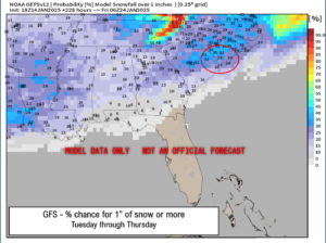
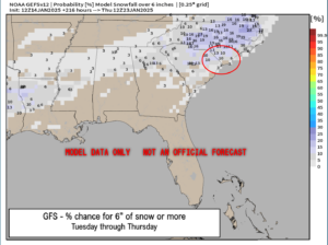
The GEFS, blended together, gives us a 29% chance at seeing at least 1 inch of snow, and a 10% chance of seeing at least 6 inches of snow.
Here’s the thing, my friends, we’re still a week out. We’re talking about weather systems that have not even developed yet, and might not develop at all. IF the storm develops, it needs to take a very specific track just far enough offshore to keep the warm air (warm nose) away, but not so far away that there’s no moisture. A track along or ON the coast means ice to rain. An inland track means a miserable cold rain. Storm strength and track are huge unknowns right now.
I know some of yalls phone apps are talking about this apocalyptic snow event here next week. Let me give you a little “peek behind the curtain.” Weather apps are nothing more than model data, from one particular set (whether that’s GFS, ICON, Euro is up to the manufacturer). Even The Weather Channel’s app is model data only. There’s no human quality control. So the phone apps, while they’re useful for 24-36 hour forecasts, should be “for entertainment purposes only” beyond that.
Long range modeling (beyond 7 days) is also more-or-less a shot in the dark. The technology is good for looking at general, large-scale patterns, like lobes of the polar vortex spinning south out of Canada. The computing power, even in 2025, just isn’t there for the fine details of rain/snow/ice. And really that won’t be pinned down to any degree of confidence until we’re 2-3 days out from the event… i.e., Saturday to Sunday in this case.
Also… when looking at phone apps or Facebook posts showing “snowmageddon” here, think about this: How often does southeast NC truly get 6-12 inches of snow? Very, very, VERY rarely. Only a few times since records have been kept. That’s why I look at the sexy graphics with a huge bit of skepticism. That doesn’t mean it won’t happen, but the chances are really slim.
So while we can get excited (or dread) the thought of wintry weather here in ColCo next week, we need to kind of scale back that enthusiasm a little bit, not fall for the nonsense we’re seeing all over Facebook, and understand that it’s just too soon to make any call.
If the modeling and the patterns still point in this direction come Friday into Saturday, then yes, get excited, and get ready to pick up some bread and milk. Until then… “stay tuned.”
Ok friends, that’ll do it for today. Have a wonderful day, thank you for reading and supporting CCN, and as always, take care.
~Meteorologist Christopher Cawley

