Greetings friends and neighbors, welcome to your CCN Daily Weather Update for Wednesday January 8, 2025. This is a longer one, folks, but stick with me as I break down my thinking regarding Friday night into Saturday. I said the other day that “by Wednesday I’ll be able to give details.” Well, it’s Wednesday, time to put up or shut up, right?
But first…

I’m seeing so much on social media about the coming “storm” … relax. This is a “1” on the bread-and-milk rating scale. We’ll get a relatively decent amount of rain out of this, perhaps three-quarters of an inch to one inch of liquid equivalent. Not quite enough to bust the current D1 “moderate” drought we’re in, but at least it’s something.
Seriously, folks… some of the stuff on the TikTok and X and Facebook… mercy. It’s almost like hurricane season with “meteorologists” coming out of the woodwork.
TODAY, THURSDAY, MOST OF FRIDAY: Really there’s not an awful lot to talk about. It’s cold, thanks to a huge Arctic high pressure center flexing it’s muscle over much of the eastern third of the country. A weak little shortwave (disturbance) will drift through later this evening, reinforcing that cold air.
Speaking of cold… school bus-stop temperatures early Thursday morning will range from 18-23 degrees. Bus-stop temps early Friday morning should range 20-24.
Highs might not even reach 40 on Thursday. For reference, the normal high for Whiteville is 55, with a normal low of 32, and these values represent the lowest “normals” for the calendar year.
We won’t see 55 for a high anytime in the foreseeable future. Long-range modeling suggests maybe the 19th or 20th at the earliest. But I digress.
FRIDAY PM THROUGH SATURDAY: Ok. Let’s talk about our “storm” for Friday night and Saturday.
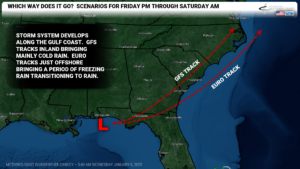
The Arctic high pressure center moves off the coast early Friday. In the meantime, an area of low pressure will move eastward along the Gulf coast. The GFS wants to track this low along the lowlands of SC and then just east of the I-95, and the model has been reasonably consistent for several runs at this point. The European has also been quite consistent keeping the center just offshore. The ramifications of the different storm tracks are significant — the GFS track indicates an all-rain event from start to finish, whereas the Euro would indicate some frozen precipitation at the start, ending as rain. Other global models, such as CMC (Canadian) and the ICON suite (German) kind of split the difference all over the place.
All of the short-term guidance continues to be relatively quick with moving precip into the area later Friday afternoon… while at the same time illustrating dewpoints in the single digits (indicating very dry air overhead). The radar might indicate precipitation falling at suppertime, but it will likely be what is known as virga — precip falling from the cloud and evaporating in the middle levels of the atmosphere. That’s significant, because it causes cooling of the atmosphere closer to the ground.
For my forecast I am going to hedge my bets on the European guidance, and assume a track perhaps just offshore.
Eventually the column of air will moisten enough to support precip reaching the ground. I believe our temps are going to be right on the borderline — surface temp perhaps 30-32 degrees while temperatures 1000 feet up run between 35-40 degrees. Precip falls from the cloud as snow, melts in this warmer air layer, becoming rain, and then reaches the sub-freezing surface, forming a glaze on contact. This is freezing rain, folks, and what I believe to the most likely scenario for our county.
Meanwhile, the “warm nose” (that relatively warmer layer in the middle layers of the atmosphere) becomes more and more dominant, quickly reaching cloud to ground, turning any leftover freezing rain to just cold rain. I believe this transition will take place around or shortly after midnight Friday night.
In short, I don’t believe we’re going to see any snow at all here in ColCo, nor do I believe we’ll see a long-enough stretch of freezing rain that it will cause any significant disruptions or hazardous travel. Bridges and overpasses may be a little dicey late Friday evening.
This is all subject to change depending on the actual storm track. If the track goes even farther offshore by, say, 50-100 miles, then this whole forecast goes out the window and we’re looking at a couple of inches of snow here. If the track follows GFS, forget the freezing rain scenario completely, it’s just going to be a cold rain.
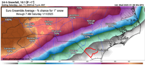
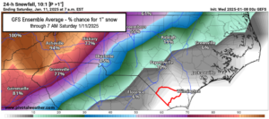
For the sake of completeness and full disclosure, I have attached here the GFS and European model ensemble averages, the percent probability of 1 inch of snow. Columbus County is outlined in red for easy reference.
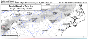
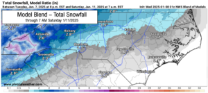
The model blend (which is a blend of ALL of the available modeling) freezing rain and snow maps are shown below.
The model blend says that, sure, perhaps extreme northern ColCo gets a hint of snowfall. But I just don’t think it’ll happen. Maybe I’ll end up eating my words.
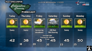
No matter what, everything transitions to all rain by time you wake up Saturday morning, with occasional rain quickly ending by roughly lunchtime. We should see partly sunny skies during the afternoon hours, and our highs should be in the mid 40s. Again, if the storm track is farther offshore, throw all of this in the trash.
After this system, a continuation of below-normal temps is likely to resume.
Giving a quick glance at super-long-term Euro and GFS runs, it looks like we’ll be in a rather prolonged dry spell running at least toward the 20th. But take that with grains of salt — any modeling beyond 7-10 days is nothing more than a throw of the dice.
Here’s your 6-day graphic.
That’ll do it folks. Thank you for reading, and as always, take care!
–Meteorologist Christopher Cawley

