
Greetings folks, and welcome to your CCN Daily Weather Update for Monday March 31, 2025.
WEATHER ACTION DAY (AND NIGHT).
This weather update is sponsored by Freedom Insurance of Whiteville. Protect what matters with Freedom Insurance. Life is full of surprises, but with Freedom Insurance, you’ll always be prepared. Whether it’s your home, car, business, or health, we provide customized coverage to keep you and your loved ones secure. Contact Freedom today at 910-640-2828!
Here’s today’s Bottom Line
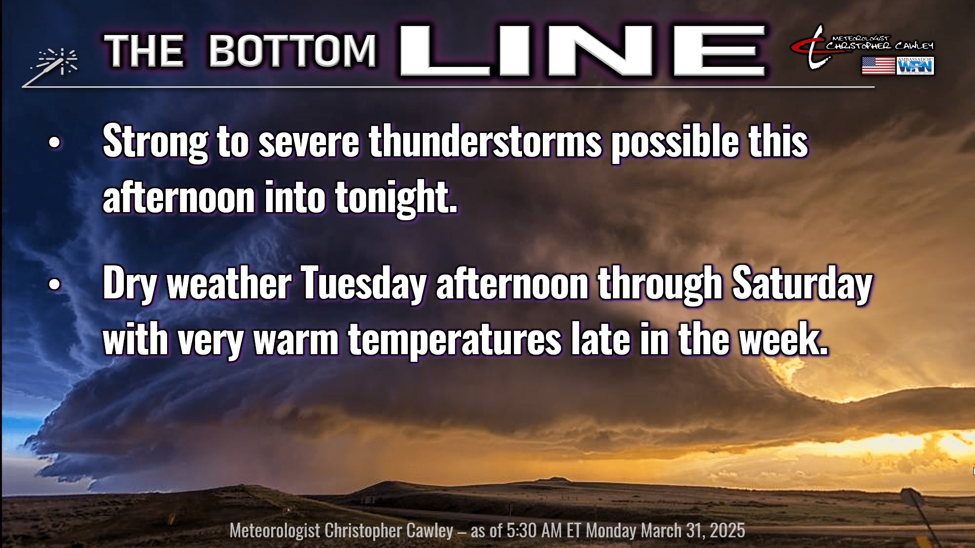
March goes out with a bang today as we’re staring down our third severe weather threat of the season. So let’s dive right in.
SEVERE WEATHER PARAMETERS:
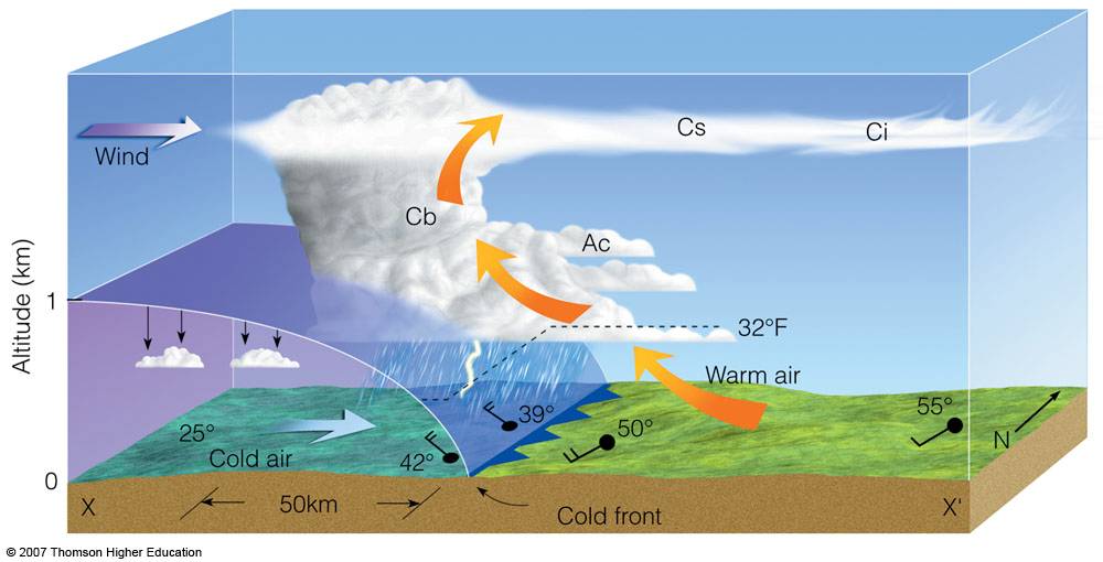
1. Source of lift. That’s easy, the approaching cold front. It’s a strong one, and we’re firmly in the warm/humid sector. A cold front acts as a source of lift because the denser, colder air mass pushes under a warmer, less dense air mass, forcing the warmer air to rise, which can lead to cloud formation and precipitation. In this case “colder air mass” is relative — it’s not going to be “cold” (like winter cold) behind this front… but definitely cooler and much less humid. Anyway, when a cold air mass encounters a warm air mass, the colder, denser air acts like a snowplow, pushing the warmer air upwards. Lift.
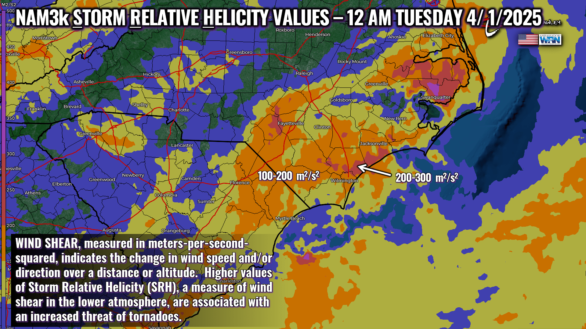
2. Shear. Bulk shear, which is the overall difference in wind speed and direction between two atmospheric levels, looks like it will hold between 50 and 70 knots late Monday afternoon into the overnight hours. Storm relative helicity values of 100-200 m2/s2 occur around or shortly after midnight, representing the peak shear values. Why does shear matter? Stronger shear, especially in the lower to middle levels of the atmosphere, is often associated with the development of supercell thunderstorms, which can produce tornadoes. Storm relative helicity measures the potential for rotation within a storm.
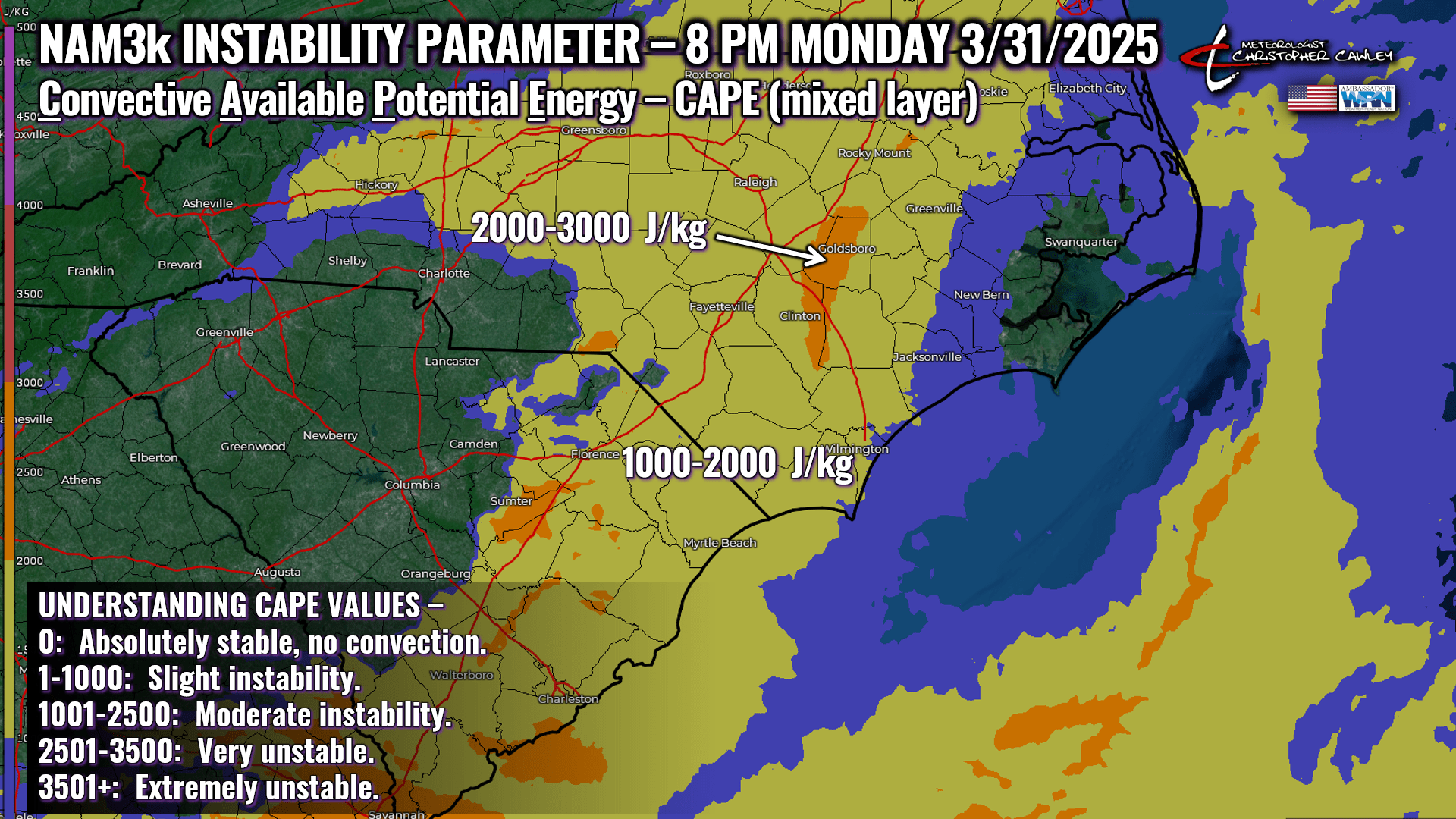
3. Instability. The instability peaks during the mid-evening hours, between 7 PM and about 10 PM from west to east. CAPE, or Convective Available Potential Energy, measures the amount of energy available for thunderstorm development, indicating the potential for strong updrafts and severe weather. Our instability values (measured in Joules per kilogram) look to max out in the 1300-1600 range, which is considered “moderately unstable.”
All three main ingredients listed above are in place for a severe weather event, with the window being mid-afternoon through the early overnight hours. “Discrete cells,” or in normal-people-language, individual storm cells, lifting quickly from south to north are possible beginning in the mid-afternoon hours. These are not certain, and are absolutely impossible to predict ahead of time. These cells, though, if they develop, are the ones we would need to watch very carefully for tornado development. If they form, they will move very quickly from south to north, and any warnings will have very little lead time.
The second severe weather potential will come in the form of a convective line (maybe more than one) that will move from west to east during the late afternoon through the evening/early overnight.
Working AGAINST a significant widespread severe weather outbreak is the fact that the latest short-term modeling shows a disconnect between the time of the peak instability and the time of the peak storm relative helicity (a shear value). If I were rooting for a dangerous severe weather outbreak, I’d want these to overlap. But they’re off by about 4 hours (at least in the modeling at the time of this writing), with the instability peaking and dying during the evening, and the storm relative helicity peaking around or shortly after midnight. If the guidance shows these coming into better agreement, that could spell trouble.
I’m also not very much in love with the disagreement in the short-term guidance on the convective squall line potential. The NAM modeling, as of this writing, suggests a convective line impacts our area 7-10 PM, while the HRRR suggests the convective line(s) go off the coast entirely before midnight, ending the event.
There’s also a marine air layer that remains in place, especially closer to the coast. The ocean is still cold (relatively speaking) and that very low-level stable air will play some part in all of this. Does the marine air layer make it into Columbus County? It definitely would not surprise me to see it over the eastern half, say east of US-701. If this occurs, that puts a lid on the convective potential.
THREATS: The main storm threat, by far, will be damaging to destructive wind gusts with the convective line(s). There is also a threat for larger hail and tornadoes in any discrete / individual cells that develop well ahead of the convective line(s). I’m going to assign a large window for threat, running 12 hours from 3 PM to 3 AM to account for the lower-than-normal confidence in how this plays out.
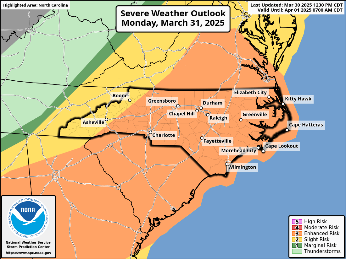
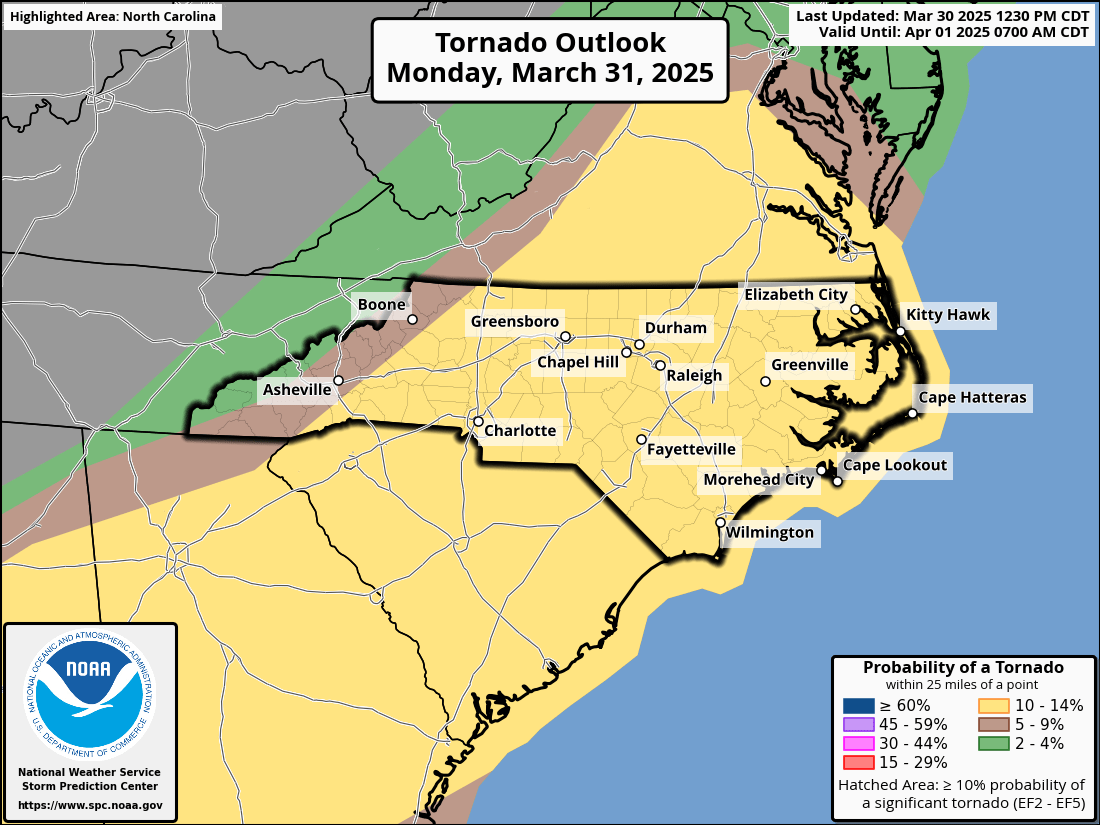
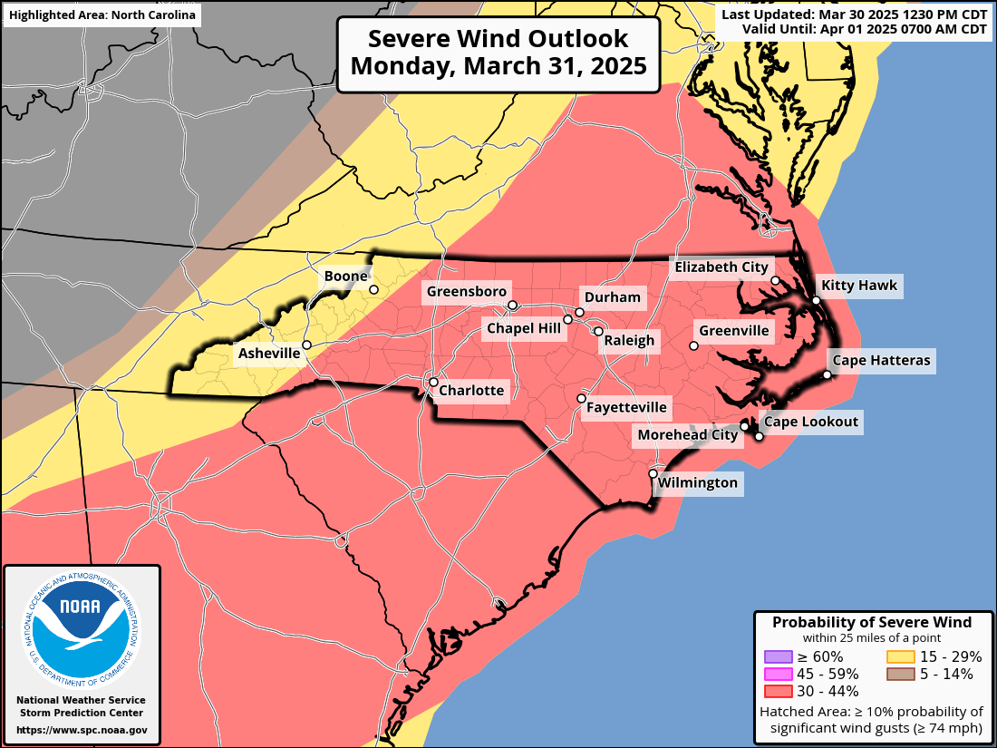
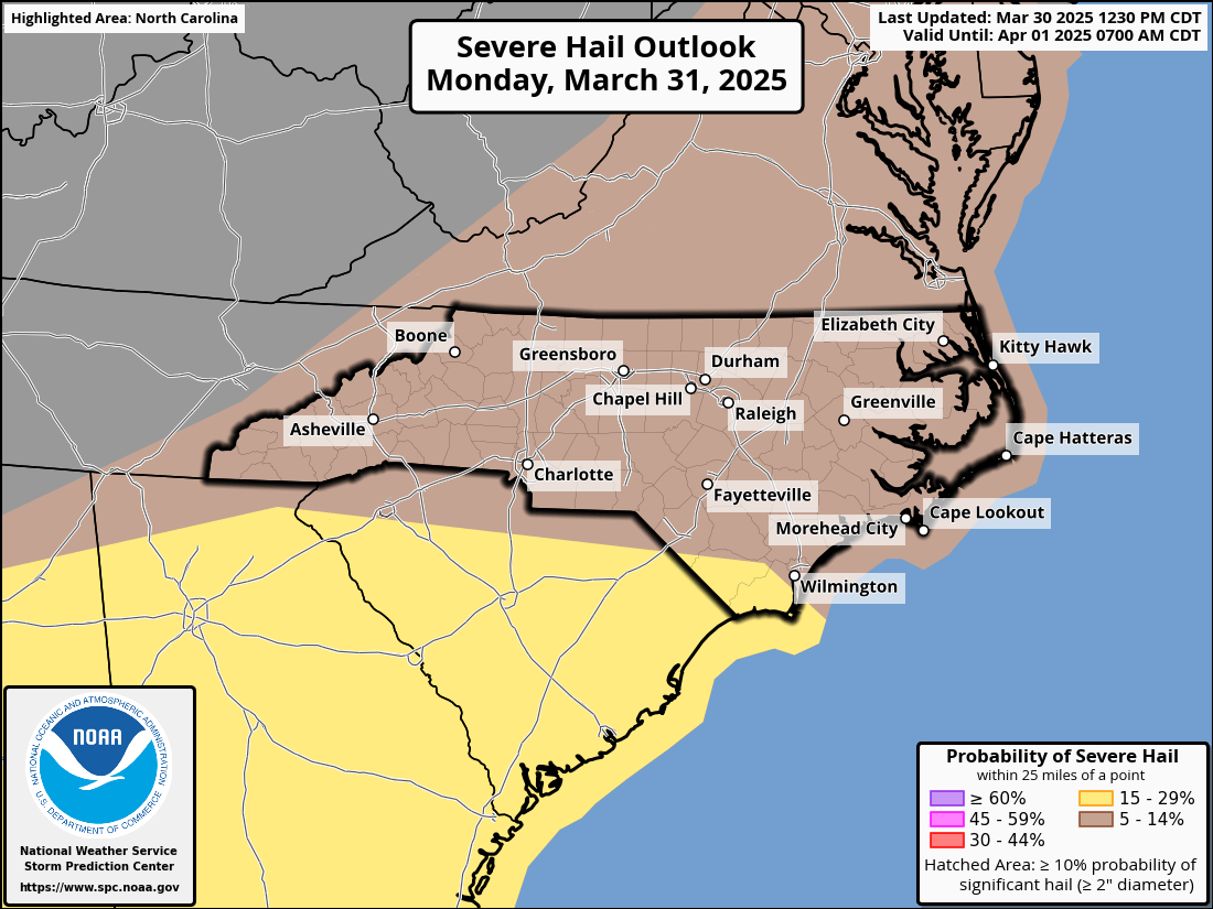
The NWS Storm Prediction Center, as of this writing, has our area under a LEVEL THREE (“enhanced”) severe risk for today. This means that numerous severe storms are possible; some could be more persistent and/or widespread, and a few could be intense. SPC outlines Columbus county under a 10% to 14% chance for a tornado, a 30% to 44% risk for severe wind (greater than 58 mph), and a 15% to 29% risk for severe hail (greater than 1 inch in diameter).
I know — believe me, I know — the last two “severe weather events” peetered out and were gigantic nothingburgers. We dodged a couple of bullets. Sooner or later one will hit the target so don’t take this lightly. Today (well, more tonight) remains a “Weather Action Day” because of the potential for significant damaging winds and tornadoes. Stay weather aware, and make sure you have multiple RELIABLE ways of getting weather alerts. THE WEATHER APP ON YOUR PHONE IS **NOT** A RELIABLE SOURCE FOR ALERTS.
Behind the front, dry weather is expected through the end of the week with temperatures warming to well above seasonal normal values… no that “90” is not a typo. While hot temperatures occur Friday into Saturday, there are some model indications of a MASSIVE pattern change going into the following week, in the form of significantly colder temperatures and a possible frost threat in the April 8-10 timeframe.
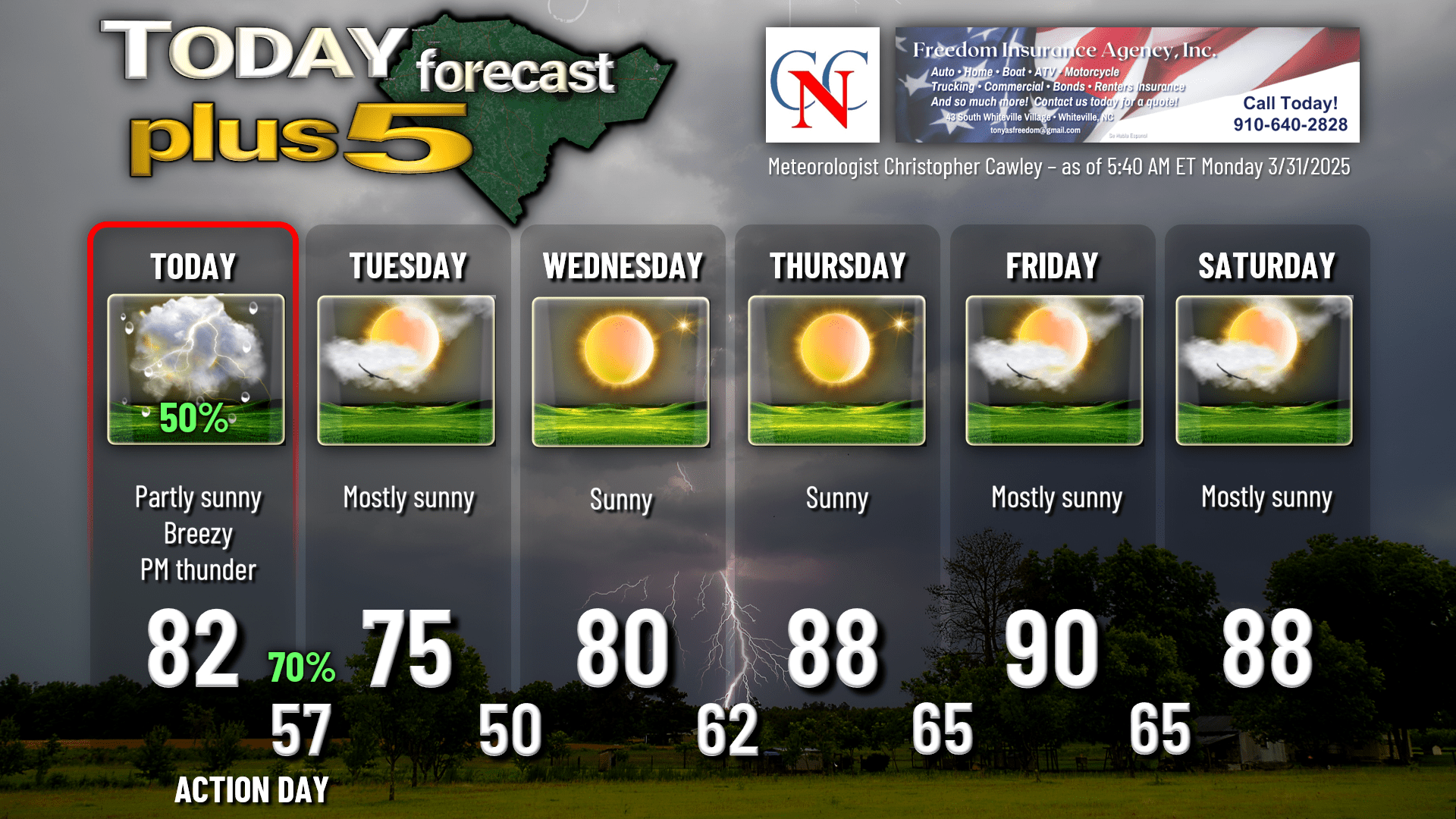
Here’s your Freedom Insurance Today-plus-Five forecast:
That will conclude today’s report. I know this was really long, with a lot to talk about, and thank you for reading. Stay weather aware this afternoon and this evening, and as always, take care.
~Meteorologist Christopher Cawley