Hello friends and followers, it is now time for the CCN Daily Weather Update for Thursday April 3, 2025.
This weather update is sponsored by Freedom Insurance of WhitevilleFreedom Insurance of Whiteville. Protect what matters with Freedom Insurance. Life is full of surprises, but with Freedom Insurance, you’ll always be prepared. Whether it’s your home, car, business, or health, we provide customized coverage to keep you and your loved ones secure. Contact Freedom today at 910-640-2828!
STATISTICS FOR WHITEVILLE – Wednesday April 2, 2025.
High: 80.6°F at 4:21 PM (normal is 70)
Low: 53.5°F at 7:24 AM (normal is 44)
Precip: 0.00 in
View live, real-time weather data for Whiteville on my College Street Weather Station.
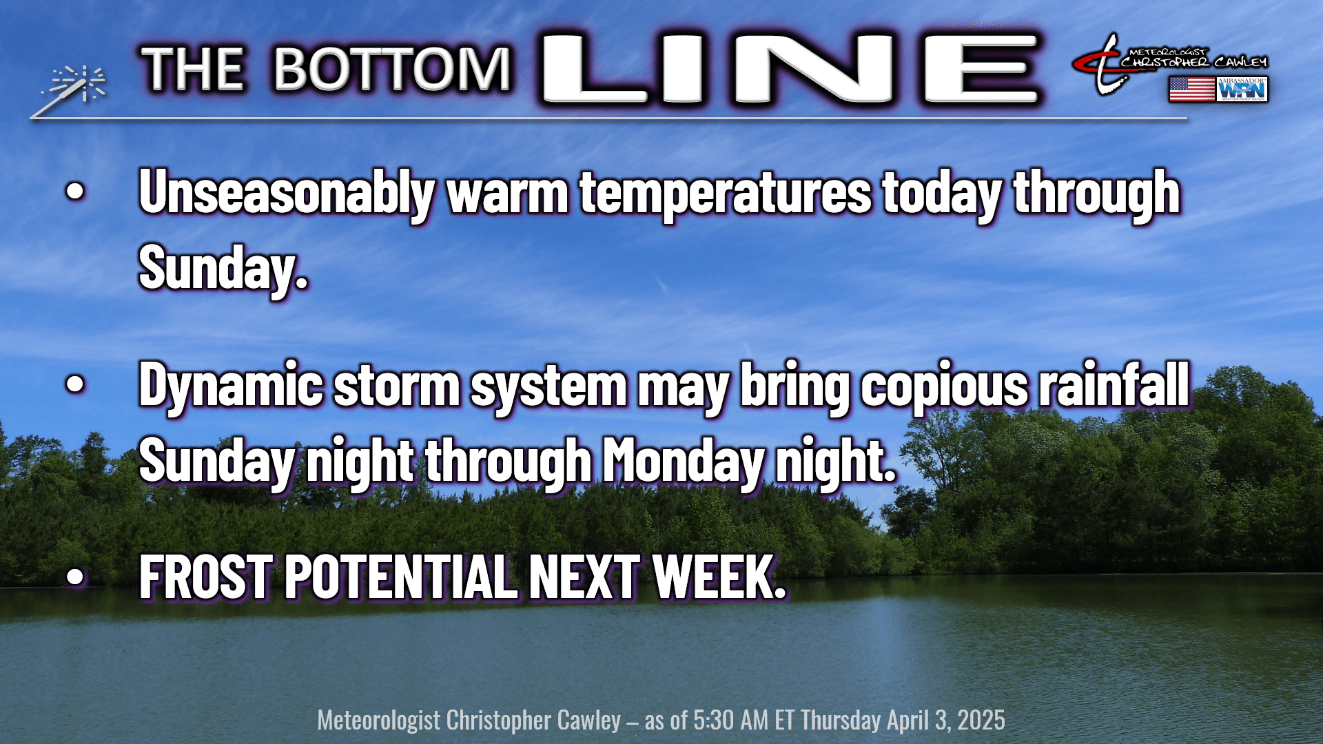
Here’s today’s Bottom Line
THE HEAT IS ON. A warm front lifted north over the area while you were sleeping. Heights are rising – rapidly – as a massively strong upper-level high pressure ridge builds over the Atlantic Ocean near the Bahamas. This will lead to temperatures resembling what they should be in late June instead of early April.
We’re truly going to have “variably cloudy” skies today through the weekend. Lots of stratus will develop during the overnight hours. When considering a stratus cloud, think of a thick “blanket” of cloudiness. This will trap warm and very humid air at the surface resulting in areas of fog at times. Fog is nothing more than stratus cloud on or just above the ground level.
In the morning, the heat from our resident G-type main-sequence star, also informally known as a “yellow dwarf” (aka the sun) starts to “mix” the atmosphere, breaking up the fog/low stratus, giving us a mix of blue sky and bright white cumuloform clouds during the afternoon along with breezy conditions. Such is the scenario we will experience today, Friday, Saturday, and Sunday.
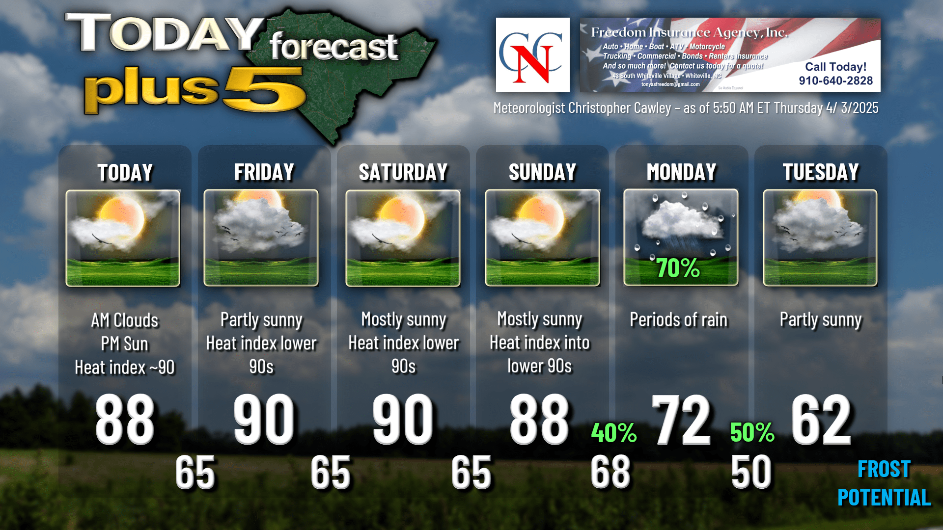
As the atmospheric heights continue to rise (the indicator of the strength of the upper-level high pressure ridge and the surface high just below it), the air develops a bit of a “sinking” motion during the afternoons. This compresses the air (think about it — high pressure = sinking air), causing it to heat up –> –> leading to temperatures flirting with the 90-degree mark across the county, especially Friday and Saturday. Throw in dewpoint values in the 60s (indicative of humid air), our heat index values will rise into the lower and possibly middle 90s. That’s far, far below the “heat advisory” criteria by the NWS — we have to be 105 or higher for 3 hours to trigger an advisory. As this is our first encounter with these conditions since last October, it’s going to feel really hot outside, and you might want to use a little bit of caution, or at least listen to your body, if doing any outdoor activities.
It’ll be MUCH cooler at the beaches thanks to the colder ocean water. There will also likely be considerably more cloudiness along the coast thanks to the colder shelf waters. So if you’re going to the Azalea Festival in Wilmington, prepare for a good 10-degree temperature difference from Whiteville to Wilmington, and another 5-8 degrees if you go out to the beaches.
SUNDAY NIGHT THROUGH MONDAY NIGHT RAIN SYSTEM? Next up… a complex storm system has the POTENTIAL to bring copious rainfall to our area late Sunday night and then again Monday through Monday night. A strong cold front will approach the area late Sunday. Moisture will be steadily increasing Sunday afternoon and evening. Scattered showers and isolated thunderstorms are possible along and just ahead of the front on Sunday night.
Being a meteorologist is more than just looking at model data and saying, “yep, sounds good.” Meteorologists use past experiences and analogs to generate forecasts as well. “Analogs” means similar events that have taken place in the past. So… past experience with these tells me that an area of low pressure “is probably” going to come together on the front and lift quickly northward along the coast. This is not shown in ANY of the model guidance, but is something I know to have happened with similar setups in the past. The sharp contrast between summer and much colder air over the ocean can also work to cause low pressure to form. Should this be the case, timing and location are the keys. Remember the snowstorm in January, and how I said the low had to “thread the needle just right,” well, we have a similar case on Monday. Depending on how quickly the low rides the frontal boundary (assuming a low forms in the first place), and the location of that low, our area could receive some very beneficial soaking rainfall Monday into Monday night. I’m going out on a limb with this one, folks, on pure gut instinct. It may not happen… it is FAR from a certainty. Also, the front may push far enough off the coast that by the time low pressure DOES form, it’s too far away to make any real impact here. Either way I just have the feeling (I know, very “unscientific” of me) that something will form on this front. Thus, I put a 70% on the chart for Monday.
FROST POTENTIAL NEXT WEEK: Unseasonably hot temperatures will quickly give way to unseasonably cold temperatures after the front moves through. Monday’s highs will likely be around 70, and that’ll be the last time for several days. All indications are that highs will struggle to reach the lower 60s Tuesday-Thursday thanks to another unusually strong high pressure, this time of Canadian origin. Low temperatures early Wednesday and early Thursday are likely to be in the middle to upper 30s in the coldest areas. Model blends have a pair of 38’s for Whiteville on Tuesday night and Wednesday night (early Wednesday and early Thursday morning). Again, past experience, having observed this now for the better part of 15 years, tells me our temperatures will go colder than those values across ColCo…. so at least scattered frost is a very real possibility those mornings.
Here’s your Freedom InsuranceFreedom Insurance Today-plus-Five forecast:
That will conclude today’s report. Thanks for your time, and as always, take care!
~Meteorologist Christopher Cawley


