Greetings folks, and welcome to your CCN Daily Weather Update for Tuesday April 1, 2025 — no foolin’!
This weather update is sponsored by Freedom Insurance of Whiteville. Protect what matters with Freedom Insurance. Life is full of surprises, but with Freedom Insurance, you’ll always be prepared. Whether it’s your home, car, business, or health, we provide customized coverage to keep you and your loved ones secure. Contact Freedom today at 910-640-2828!
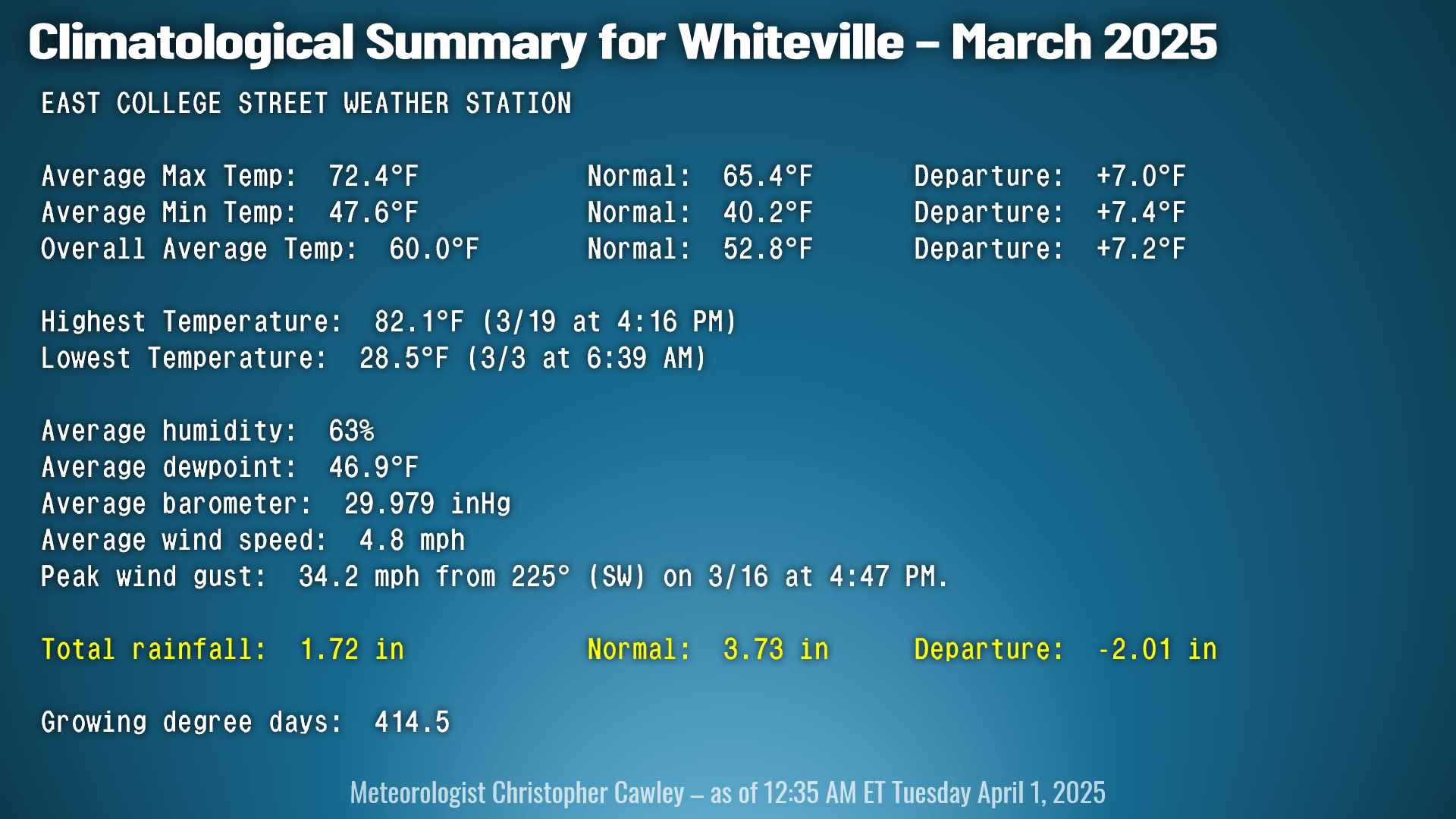
It’s a new month so let’s take a quick look at some statistics for Whiteville. First up to bat is the month of March where temperatures averaged out to be quite a bit above seasonal normal values, and our rainfall deficit continued to increase.
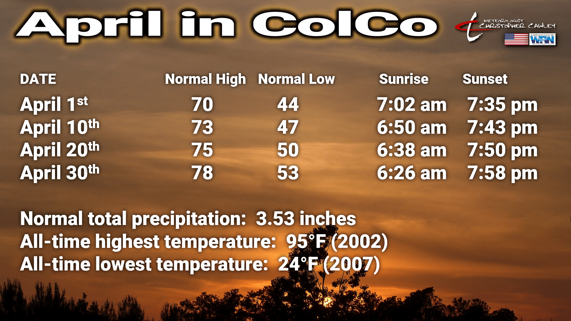
Looking at April, we see a steady increase in normal temperatures and daylight, and we should receive about 3.5 inches of rainfall for the month.
That all-time record high … I don’t think we’re going to break it on Friday but we’re going to come close. More on that down below.
As always, you can view real-time weather information on my station on East College Street by clicking THIS LINK.
Here’s today’s Bottom Line:
We dodged another severe weather bullet here yesterday; there were some wind damage reports in Horry County, but nothing was reported here in ColCo. That’s good. We did pick up just under half an inch of rainfall, and while that’s not a drought-buster by any means (not even close), every drop counts.
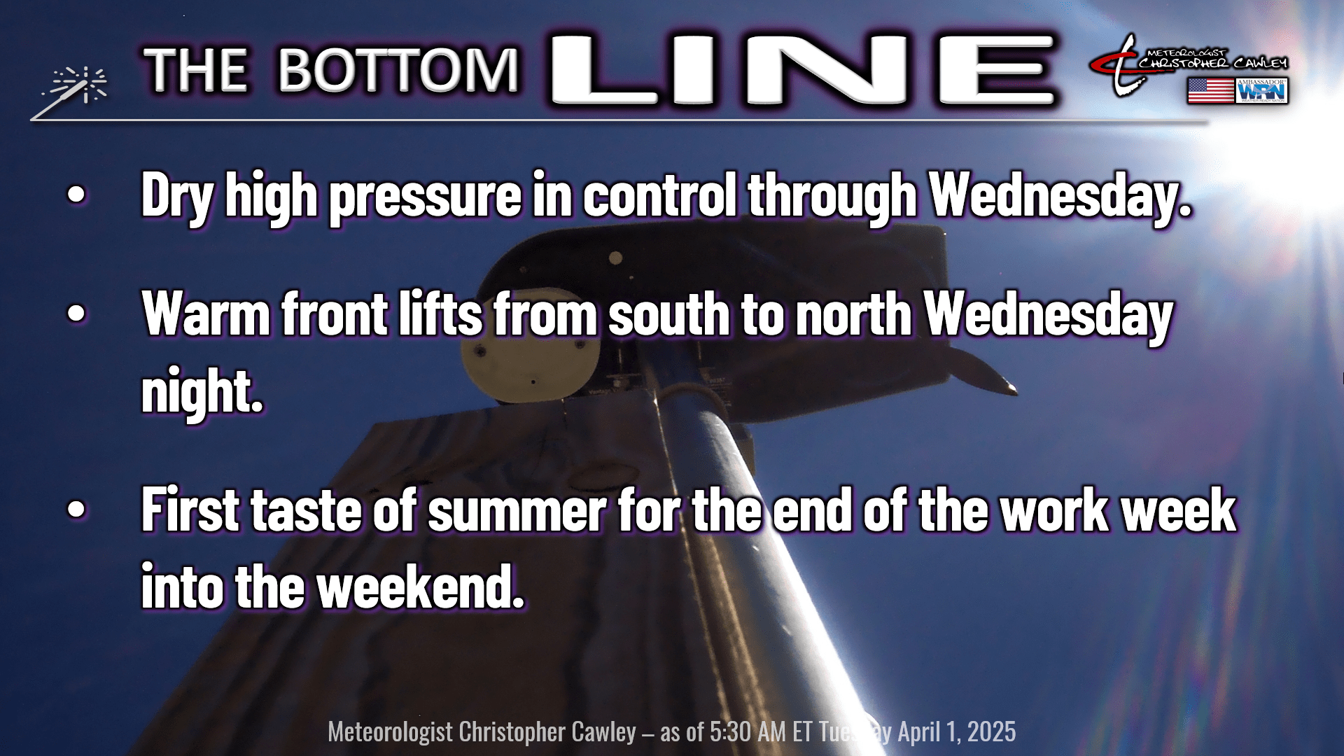
Rain chances are very low (almost zero) between now and Sunday night.
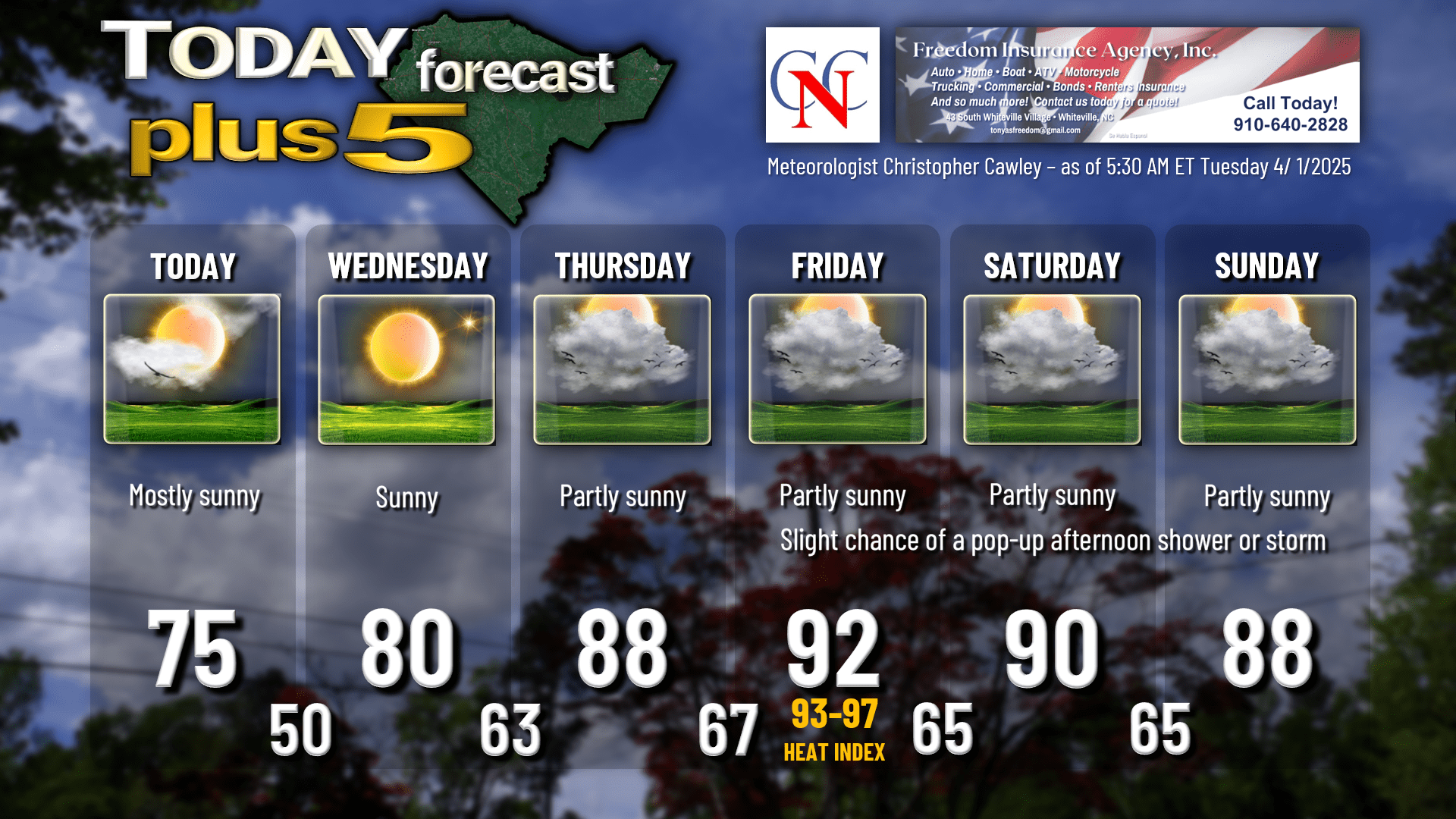
High pressure will dominate our weather today through Wednesday bringing delightful spring conditions and temperatures just a few ticks above normal. Northerly winds today will become somewhat easterly by Wednesday afternoon. If you’re headed out to the coast, expect temps to run several degrees colder.
A warm front lifts quickly over the area Wednesday night into early Thursday. This will bring a good deal of cloudiness thanks to mid-level moisture streaming northward from the Gulf. The storm system to which this front is attached is significant — more on that in a few moments.
Then… a taste of summer. Strong… and mercy do I mean strong ridging high pressure off the coast will bring a deep, moist southerly flow to the area. This Bermuda high will flex its muscle Thursday, Friday, and Saturday, bringing potentially record high temperatures to the area.
As a side note for the weather nerds reading this, the high pressure is possibly going to be record-setting. “Heights” at the 500-mb level (which is considered the “middle” of the atmosphere) are likely to reach or exceed 600 dam (decameters). That is ~SIGNIFICANT~. The 500-mb height is related to the average temperature of the air “column” between the surface and that 500 mb level (in this case, about 6000 meters, or roughly 19,690 feet above sea level). Higher “heights” generally indicate warmer temperatures. A “normal height” at the 500 mb level ranges between 460 dam and 550 dam (4600 meters and 5500 meters). 600 dam is way, way, way above what would be considered “normal” high pressure.
You can read a tutorial on geopotential height and learn a little bit of the science of Meteorology at THIS LINK, written by one of my former professors, Meteorologist Jeff Haby.
Anyway, this all spells an early taste of summer heat here in Columbus County, especially Friday and Saturday as we are on the western rim of the “heat dome.” Heat index values on Friday will likely be in the mid 90s. No, that isn’t a typo.
MEANWHILE…. an area of low pressure will be getting it’s life in order by late this evening over the central plains. This complex system will lift northeastward into the Great Lakes region by Thursday (that’s also going to be responsible for the warm front lifting over our area late Wednesday night). The high pressure dome is going to keep the attendant cold front at bay for several days as this system gets kind of “slung out” going into the weekend. The whole system finally orients itself along the eastern seaboard by later Sunday afternoon as the Bermuda high pressure starts to push farther east, thereby releasing us from its grip.
Multiple areas of low pressure will be riding northward along the frontal boundary as it crosses our area late Sunday night or on Monday (there’s some timing disagreement in the modeling). Depending on the location of these lows, we could see a decent rainfall here Sunday night into Monday. If we can get things to set up just right, it could be on the order of an inch or two of rainfall. If the low center exists to our north, however, as some of the guidance wants to suggest, we’ll simply have a line of convection with the front and that’ll do it. Let’s hope for the former. It’s too far out in time to pin down.
The passing of the front will mean an introduction of MUCH cooler temperatures… temperatures actually running a fair bit below normal thanks to Canadian high pressure. Model blends suggest highs in the 60s NEXT week… with a very slight FROST POTENTIAL (!!) in the April 8-10 timeframe. I’m not sure that I’m sold on the strength of the high quite yet but will definitely be watching this trend.
One thing about my forecast below, I’m going with what meteorologists call “silent POPs” in the business. Silent POPs means that there’s a slight chance that there could be an isolated shower or storm but the chance is not enough that it’s worth putting in the actual forecast. Right? I know what you’re thinking. This means that the POP (Probability of Precipitation) is around 10%. That’s what I’m going with Friday through Sunday. In other words, it’s likely going to be completely dry, just about everywhere, but uncle Larry’s farm on Rough and Ready Road got about half an inch of rain Friday afternoon.
Here’s your Freedom Insurance Today-plus-Five forecast:
That will conclude today’s report. Thanks for your time, and as always, take care!
~Meteorologist Christopher Cawley