A very good evening to you all, Meteorologist Christopher Cawley here with tonight’s update, the final one for the month of October, October 31, 2024.
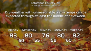
Cody Rhodes would say, “what do you want to talk about?” There’s certainly not much to talk about in terms of the weather. Dry high pressure will allow a dry cold front to cross the area on Saturday, and then reassert strong control through just about all of next week. Dry weather and unseasonably warm temperatures will be the result.
Longer-range modeling hints that we might get some rainfall in here toward the end of next week and into next weekend (November 8-10 ish). That would certainly be nice.
Outside of that, don’t forget to set the clocks back Saturday night and enjoy that extra hour of sleep.

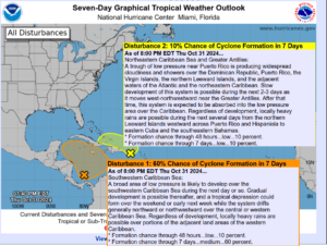
Looking at the tropics, we have a couple of areas of disturbed weather to talk about this evening. The first one is the one we’ve been watching for several days now. Low pressure is still trying to get organized in the Caribbean Sea, and the NHC now gives this a 60% chance of becoming a tropical system over the weekend. There are no spaghetti plots with this as of yet (it isn’t classified as an “invest” as of the time of this writing), but the modeling suggests this drifts north and eventually northwest. If we really want to get speculative, this could thread the needle between the Yucatan and Cuba and possibly enter the Gulf … but that’s way, way out in time and only speculation.
Disturbance #2 is associated with a trough of low pressure near Puerto Rico. This will drift northwest, north of Greater Antilles, and then get swallowed up by another (non-tropical) area of low pressure. NHC gives this a 10% chance of becoming tropical… but even if it does, it won’t have a very long life expectancy. No worries.
There’s another disturbance in the north-central Atlantic that’s not even worth writing about.
Ok folks, that’ll do it for tonight. Thank you for reading and take care!


