Greetings folks, welcome to your CCN Daily Weather Update for Thursday March 13, 2025.
This weather update is sponsored by Freedom Insurance of Whiteville. Contact Freedom today for all of your insurance needs. Their professionals are 100% committed on providing outstanding customer service and working with you to establish the best policy to meet your needs.
STATISTICS FOR WHITEVILLE – Wednesday March 12, 2025.
High: 81.9°F at 4:30 PM (normal is 64)
Low: 43.6°F at 7:06 AM (normal is 39)
Precip: 0.00 in
View live, real-time weather data for Whiteville on my College Street Weather Station.
Here’s today’s Bottom Line
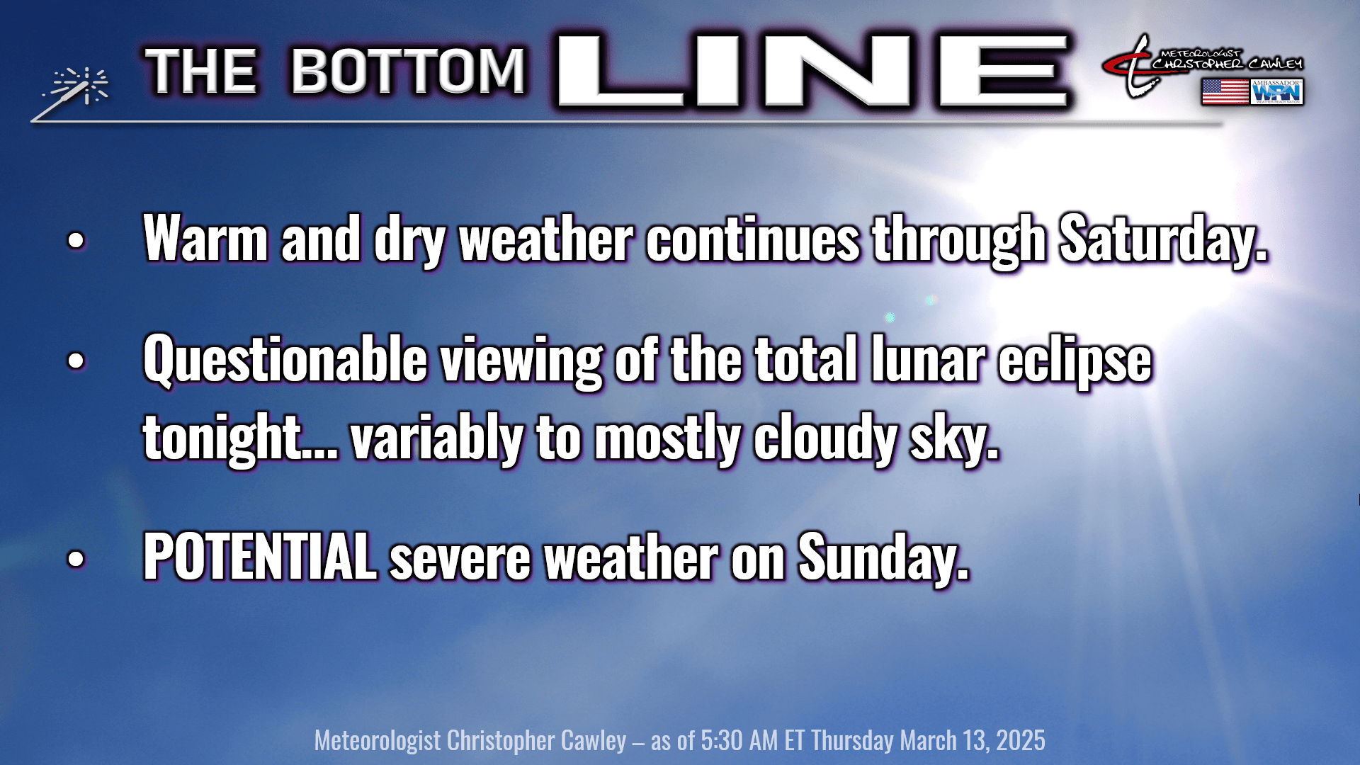
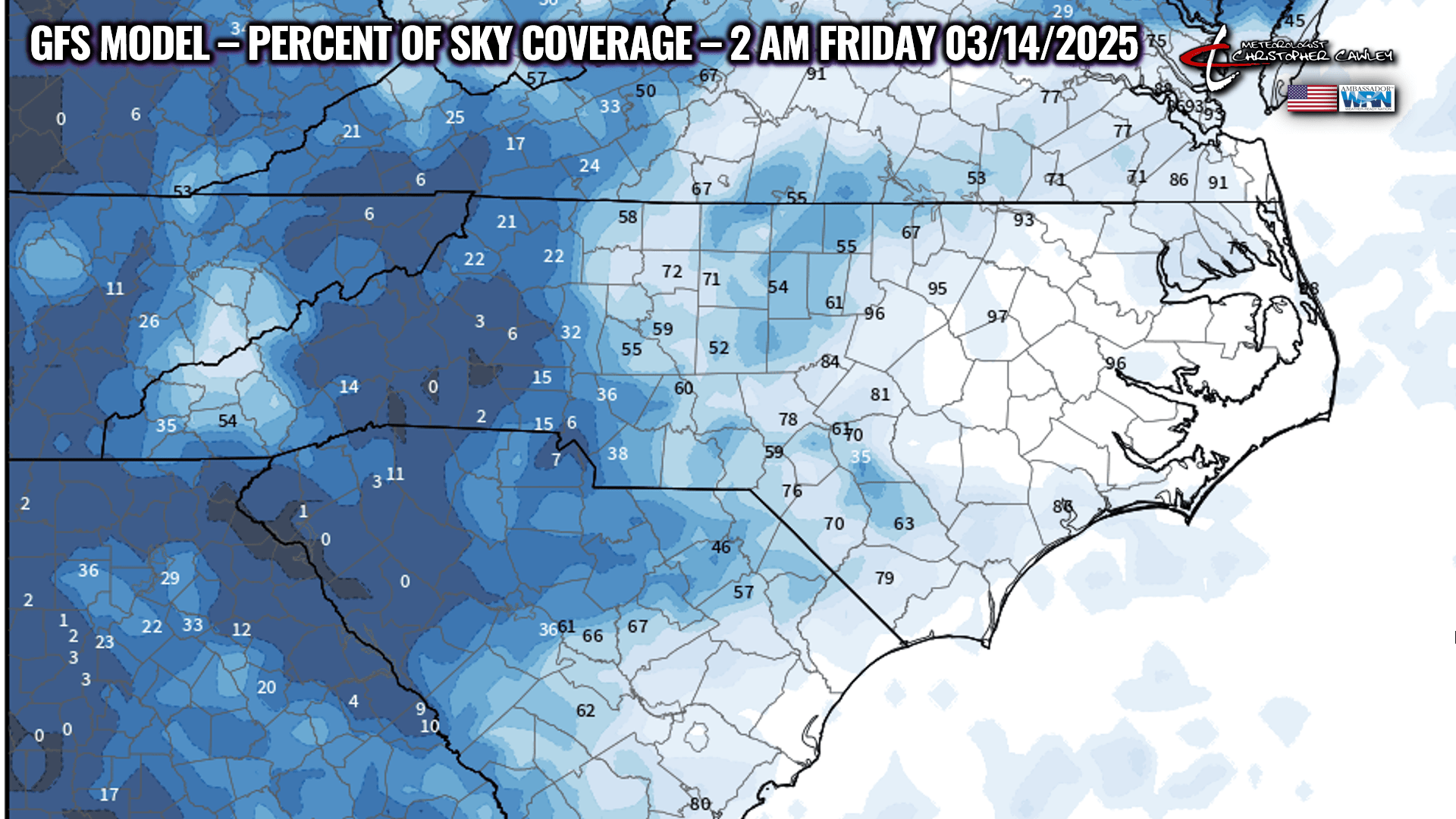
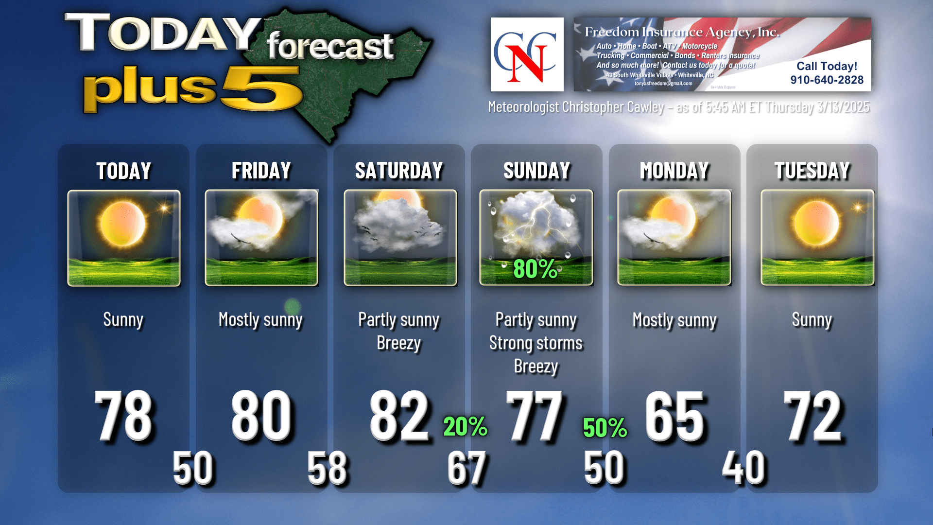
Lots of sunshine and warm temps once again today. A weak backdoor cold front will drop down from the north tonight and this will bring some cloudiness; it’s questionable as to what our sky conditions will look like during the eclipse. I think there’ll be some breaks in the clouds allowing those night owls (like me) to get some viewing.
The latest GFS model says that 79% of the sky will be covered by cloudiness at 2 AM Friday (totality begins at 2:26 AM).
Weak high pressure settles over the state briefly on Friday before a warm front lifts north during the afternoon hours. This frontal passage will be remarkably unremarkable… but our lows Friday night/early Saturday will be closer to normal values for mid-May instead of mid-March.
This warm front will be attached to an absolutely blockbuster storm system over the north-central Plains, extending northward to the Minnesota/Canada border.
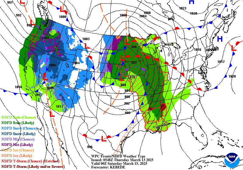
We’ll be firmly in a warm and humid sector on Saturday. Breezy to windy conditions are likely as three distinct areas of low pressure lift north into Canada (the storm centers combine and become so strong that the whole system essentially occludes itself). Severe weather is likely across portions of Alabama and Mississippi, as well as the Ohio valley, while we experience a general increase in cloudiness and humidity.
SEVERE WEATHER THREAT FOR SUNDAY. The accordant trough, one that is usually attached to areas of low pressure such as what the midsection of the country will experience, will likely become “detached” from the granddaddy low center by Sunday. However, that doesn’t mean the trough, and associated strong cold front, won’t have anything to bring to the kitchen table. Indeed the Storm Prediction Center continues to place the eastern Carolinas under a severe risk, and the GFS model surface map highlights that quite boldly…
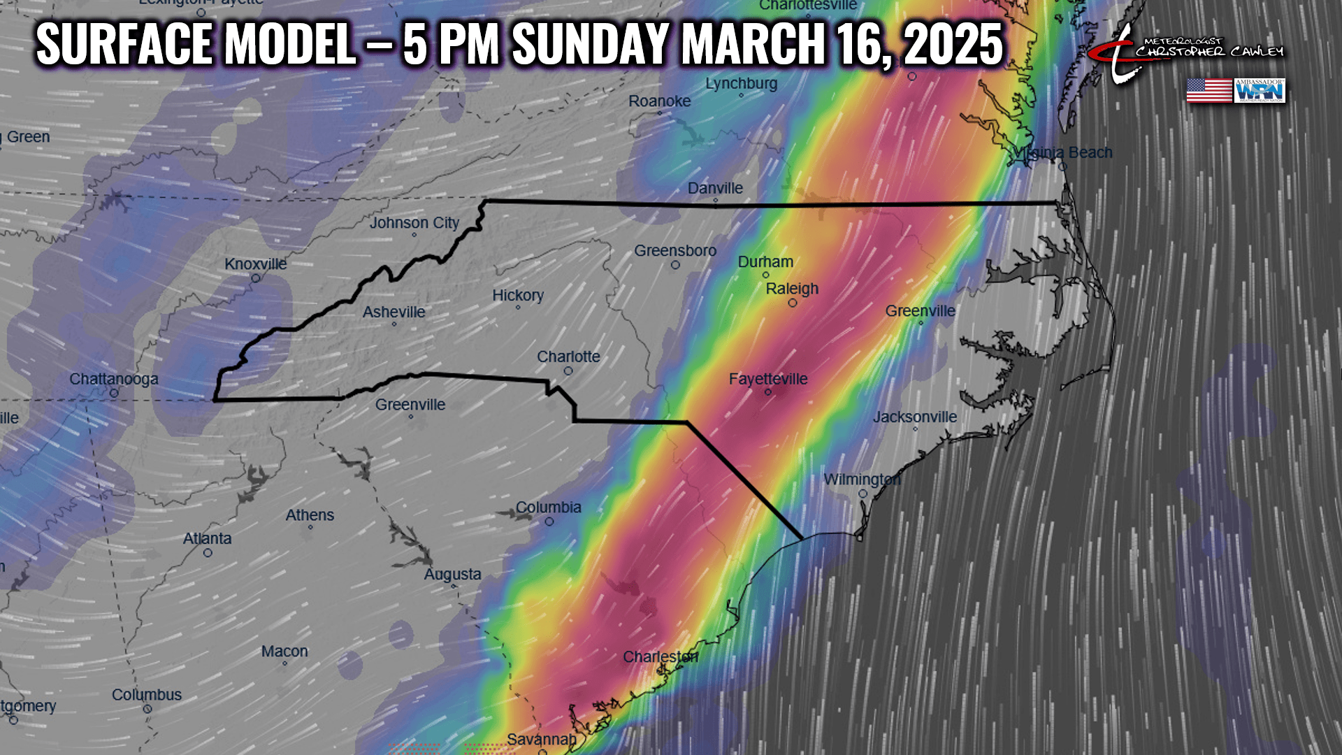
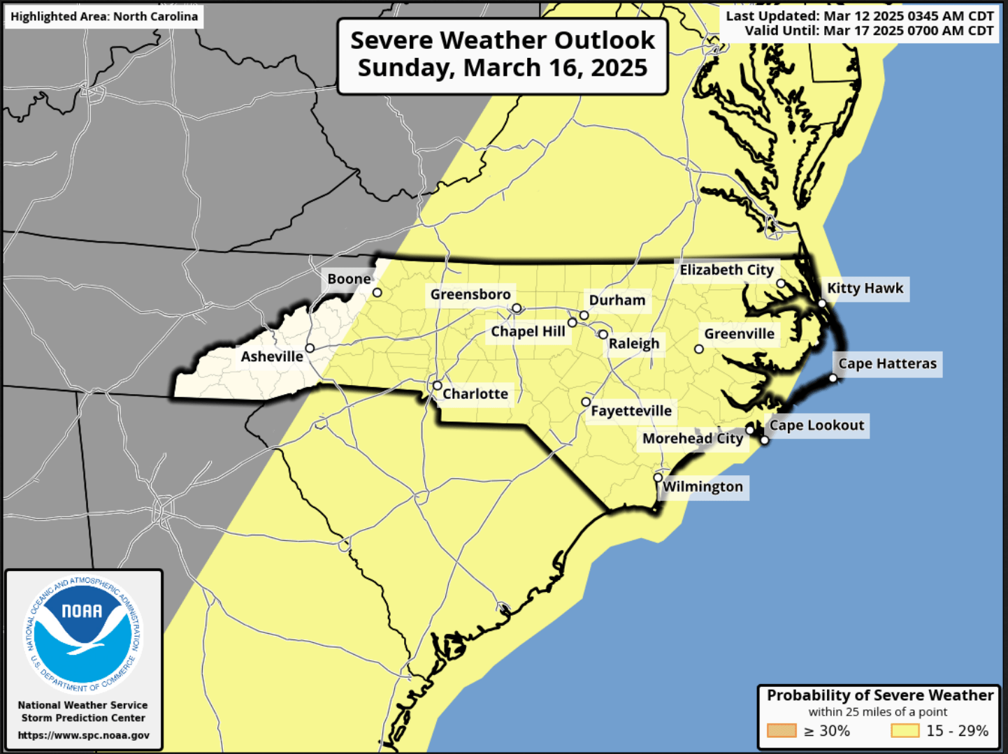
A squall line will slam its way west to east across the area, likely from mid- to late-morning into the mid-afternoon. The GFS model image above says 5 PM, but I think that’s actually going to be closer to the early afternoon hours. There’s still some time for the guidance to get its act together on timing the convective line.
Either way, a rather caffeinated low-level jet becomes established early Sunday (or even possibly late Saturday night) with very strong winds aloft. Instability is still a question, but the source of lift — the cold front — is a certainty. According to the Storm Prediction Center, “bands of convection will likely produce swaths of strong to severe gusts ahead of an eastward-advancing cold front.”
Sunday will likely be labeled as a “weather action day.”
While the front pushes offshore Sunday evening/Sunday night, the trough will lag behind, and a secondary “cold” front is likely to sweep across the state Monday morning. I think this secondary passage will be unremarkable, but our temps on Monday will be quite a bit cooler than what we’re experiencing now — actually temps will be close to normal for this time of year. High pressure reasserts control by the middle of next week with warm temps again.
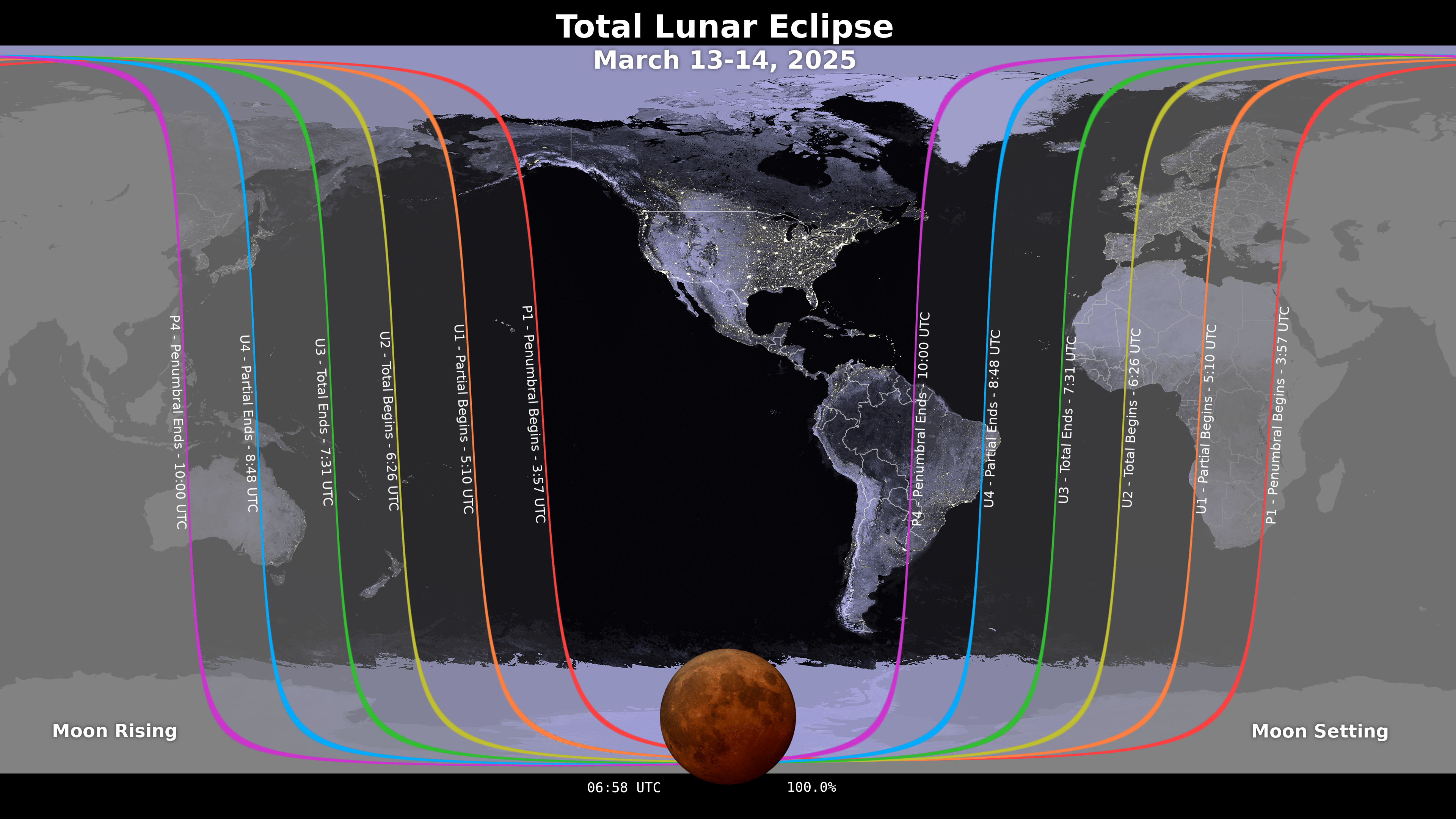
TOTAL LUNAR ECLIPSE tonight. As I mentioned, the viewing might be kind of sketchy depending on cloud cover, but it might be worth the try. The full moon will be fully enveloped in Earth’s shadow during about a one-hour period of totality during the overnight hours. The eclipse officially begins at 11:57 PM Thursday. Totality begins at 2:26 AM and ends at 3:31 AM. The penumbral phase will end at 6 AM Friday.
Alrighty readers, here is your Freedom Insurance Today-plus-Five forecast for Columbus County.
That will conclude today’s report, my friends. Thank you for your time, thank you for supporting CCN, and thank you to Freedom Insurance for sponsoring our daily reports. I hope you have a wonderful day, and as always, take care.
~Meteorologist Christopher Cawley