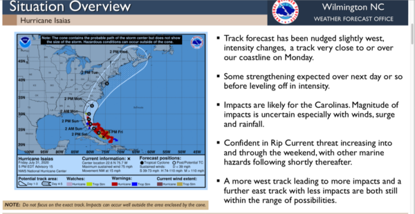
6:15 p.m. update for Friday.
Hurricane Isaias will impact southeastern North Carolina Monday afternoon, on its current track.
The National Weather Service Wilmington office sent out an update on the storm at 6 p.m. Although the storm could still shift east or west, Reid Hawkins of the NWS Wilmington office said the current path would put the storm in Northeastern South Carolina Monday morning. Rains could begin in Columbus county as early as Sunday, with tropical storm force winds throughout the evening and night Monday.
Rainfall amounts have been elevated slightly, with two to four inches likely in inland counties like Columbus and more along the coast. Due to the fast-moving forward track of the storm, significant flooding impacts are not expected.
Hawkins cautioned that the storm’s path could still change, and as little as 25 miles east or west could mean significant differences in rainfall and wind speed.
Columbus County Commissioners chair Edwin Russ said that the board has a state emergency declaration on standby, and will make a decision later, depending on the storm’s forecast path and impacts.
Another briefing is scheduled for 9 a.m. Saturday. We’ll bring you more on the storm as conditions warrant.


