Schools, government offices and many businesses are closed as Columbus County nervously eyes Hurricane Ian.
Ian is expected to come ashore between Georgetown and Myrtle Beach, S.C. around 3 p.m. today as a Category One storm. As it moves over land, Ian will begin to degrade, but Columbus County will likely see heavy rains, high winds and potentially a few tornadoes before it moves on out Saturday.
The storm was a Category Four when it came ashore at Ft. Myers and Sanibel Island, then laid west to a wide section of Florida from the Gulf Cost to the Atlantic. The storm weakened briefly, then picked up steam again after hitting the Atlantic.
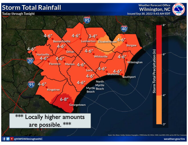
The National Weather Service issued flood and tropical storm warnings for Columbus yesterday. Brunswick County is under a hurricane warning. The heaviest part of the storm is expected Friday afternoon in Columbus.
Winds from 50 to 70 miles per our along with six to eight inches of rain are possible in some areas.
“We are monitoring the situation very carefully,” City Emergency Services Director Hal Lowder said Thursday.
County emergency officials opened the new command center for the first time Friday morning. The center is located in the administrative building that once housed the BB&T call center in downtown Whiteville.
The county, Whiteville, Lake Waccamaw and other communities declared a state of emergency Thursday after Gov. Roy Cooper did the same for the entire state. The local declarations do not prohibit travel, the sale of alcohol or possession of firearms off private property.
Local officials heeded the lessons learned during the devastating flooding from hurricanes Matthew and Florence.
The new county emergency operations center has more parking as well as a dedicated generator system.
The sheriff’s office has high water-capable vehicles and other emergency equipment on standby. The trucks and support vehicles were obtained at no cost to the county through a government surplus program.
Public works crews are on standby in Whiteville, Lowder said, but they have been working full steam ahead for several days in preparation for the storm. Mowing crew cleared and opened ditches, and street crews have been checking and cleaning storm drains in anticipation of six inches or more of rain. Some of the personnel had been working on the Mollies Branch area, which is undergoing major improvements to help pull stormwater out of the city. Other crews have been clearing channels and beaver dams in Soles Swamp in preparation for more water coming downstream.
“The city has been planning ahead for several days,” Lowder said. We’ve had crews out clearing drains and cleaning debris from the streets to help prevent drains from getting clogged.
“We do not anticipate this being anything like our historic storms,” Lowder said, “but you can never take anything for granted. One single clogged storm drain could flood an entire neighborhood.”
The Department of Transportation – which dealt with hundreds of road washouts and similar programs during previous storms – closed Byrdville-Freeman Road in Delco Tuesday due a weakened pipe under the road. Engineers felt the pipe could wash out the entire section of the road if the area gets the forecast three to seven inches of rain. Highways personnel from across the state are on standby through the weekend to respond wherever there is damage in the state.
In Tabor City, fire crews are on alert for possible heavy rains and winds. The border town will receive the first serious effects Ian if it comes ashore in the Myrtle Beach area. Tabor Rescue aggressively pursued a water rescue program in the wake of Hurricane Florence, which brought flooding to some areas of the town for the first time in recent memory.
Although significant rainfall and runoff are anticipated, the extremely dry conditions of the past summer and spring could have a benefit. In addition to a rainfall deficit, most area waterways are below their banks. Water levels of ditches in several of the most flood-prone areas in the central part of the county were well below ground level this morning, despite as much as an inch falling between midnight and dawn.
Lowder emphasized the need for people to stay home.
“There is nothing to see,” he said. “If we get street flooding or ditches overflow, then there will be enough water on the road in some places to prevent you from being able to see if the road is washed out. It only takes a couple of inches to cause a car to float, so don’t drive through water. Turn around, and don’t drown.”
Columbuscountynews.com is continuing to update closings and weather conditions as the storm moves in. Follow us on Facebook, Twitter and Instagram and tune in to WTXY 103.9 FM for the latest.