Good evening readers, Meteorologist Christopher Cawley here with tonight’s weather update, for Thursday November 21, 2024.
Our first taste of winter across the county for tonight through early Saturday thanks to a couple areas of low pressure… one over Lake Michigan and another one off the Long Island coast. A cold northwesterly wind flow will continue tonight through Friday as the aforementioned low areas consolidate over southern New England into an early season Nor’easter. This will bring snows as far south as the NC mountains, where some areas may pick up as much as 2 to 6 inches of the white stuff.
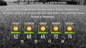
No snow here, though, just cold temps tonight and Friday. The tight pressure gradient between the Nor’easter and high pressure to our west will result in breezy conditions throughout the day on Friday. We’ll start off the day in the lower to middle 30s (I wouldn’t be surprised to see a few readings north/west of Whiteville down to around 30 tonight)… and only rise to the lower 50s with those blustery conditions. At least the sun will be shining all day.
Dress appropriately if you’re headed to Legion Stadium Friday evening to cheer on the Wolfpack. Temperatures will quickly fall through the 40s after the sun goes down, eventually bottoming out between 33 and 37 by sunrise Saturday.
The Nor’easter is in no hurry to move and by Saturday should be located off the coast of Massachusetts. The PGF relaxes a bit so Saturday shouldn’t be as breezy. Also, high pressure inching its way closer to us will allow our temps to rise back up to around 60 for Saturday.
The Nor’easter is gone by Sunday and high pressure really settles in. This will bring a very nice day with high temps in the mid 60s, which is pretty much where we should be… perhaps a degree or two warmer.
As we turn the page into next week, the high slips off the coast and a cold front begins to approach. Southerly flows ahead of the front will allow our temps to jump deep into the 70s before our next cold front moves through (with little to no moisture) on Wednesday. Temps settle back into the mid 60s for Thanksgiving with dry weather.
Looking at longer-term temperature modeling, it appears that we will enter a rather lengthy period of below-normal temperatures kicking off the first week of December. The GEFS ensembles shows our highs averaging in the 50s November 30-December 6, with sub-freezing lows around 30. That’s a bit far off in the future but is supported by the latest Climate Prediction Center outlooks showing much of the eastern part of the country in below-normal temps through the same period.
If you’re looking for snow potential, ONE (out of 50) of the European model ensembles indicates a snow potential along about December 4-5. It’s just one out of 50 model runs… and that is not a very good set of odds. GEFS/GFS ensembles have a blank screen for snow potential through December 7th.
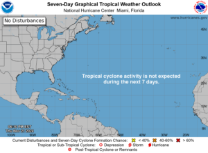
TROPICS: Nothing doing whatsoever. Global cyclone probability charts (models) show no threats through the end of the tropical storm season.
That will wrap it up for tonight’s blog. Thank you for reading, and take care!


