Happy Friday friends and neighbors, Meteorologist Christopher Cawley here with your CCN daily weather update, for Friday December 20, 2024.
Just like on Thursday, another little middle-level disturbance will push across the Carolinas today. Modeling is honing in on some shower activity from late this morning into mid-afternoon. I don’t think we’ll see a lot of rain; the showers should be light and scattered at best.
On the heels of this disturbance is an Arctic cold front, which should push offshore tonight. Rapid drying will occur by late this evening and any/all cloudiness should quickly clear out of here as that dry air pushes in. Temperatures fall into the lower 30s.
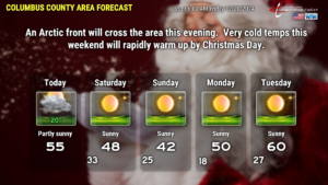
Desert-dry air will be locked in place all weekend, and really stays in place through at least Christmas Eve. It’s essentially a temperature forecast at this point. What we will have this weekend is likely to be the second-most intense cold outbreak of the season. Saturday will be brisk but sunny, highs reaching the upper 40s.
Modeling suggests that there will be some breezy conditions about 1,000 feet off the ground Saturday night. This will keep the atmosphere somewhat “mixed,” even at the surface, so our lows won’t tumble deep into the teens. Instead, look for our lows early Sunday to be in the mid 20s.
The sun is at the lowest angle of the year this weekend, and even with full sunshine on Sunday, our highs will struggle to reach the lower 40s. Sunday night will feature better radiational cooling, and our lows will be in the 15-20 degree range. Brrr.
High pressure moves off the coast on Monday. This will allow the air flow to be coming from the south, our highs jump back up to around 50 on Monday. A weak little coastal front tries to become established, and while the immediate coast may see some clouds on Tuesday into Christmas Day, I think our area will stay with full sunshine on Christmas Eve. Highs JUMP to near 60 on Christmas Eve.
CHRISTMAS DAY OUTLOOK: A southern-stream disturbance should approach from the west on Christmas. A weak area of low pressure should lift northward from the Gulf. We’ll see increasing cloudiness on Christmas Day, with the potential for rain in the afternoon… and highs should be into the lower 60s.
That’ll do it for today’s blog post. Thank you for reading, and I hope you have a great day!


