Hi everyonee, Meteorologist Christopher Cawley here with the CCN Weather Update for Monday December 30, 2024.
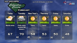
Quiet. That’s the term we’re going to use for today right through the coming weekend. It’ll be quite mild today and on Tuesday. A cold front will whisk through the area Tuesday afternoon or evening and this may bring the chance for a spotty shower or two (more cloudiness than anything else).
The lower 70s we’ll see on Tuesday will be the LAST time we see temps in the 70s for a LONG time.
No weather worries are anticipated for your New Year’s Eve celebrations. We should have partly cloudy skies through the evening with temps slowly falling through the 50s.
A secondary cold front moves through on New Year’s Day with very little fanfare, other than ushering in colder temps. We’ll drop into the lower 30s by early Thursday morning, with highs in the lower 50s on Thursday. Even colder by the weekend with highs in the 40s and lows in the 20s with clear skies.
But that’s nothing compared to what’s likely to arrive NEXT weekend…
It really is shaping up to be a kind of cold snap that only happens once every several years.
Please indulge me as I explain a little bit on how this modeling works.
The two “big” models have numerous sets of “other models,” or “members” that tag along with them. This is known as the model ensemble — think of a musical group, an ensemble, many members.
Ensembles work by using a supercomputer to gently “tweak” one or more data points, and then re-running the model. The GFS has 30 members, the Euro has 50. Each also has a control.
Meteorologists look at charts that represent “ensemble mean” (average) values. This “smooths out” some of the extremes we see with some of the ensemble runs.
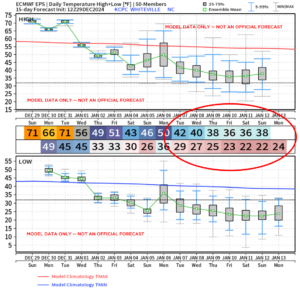
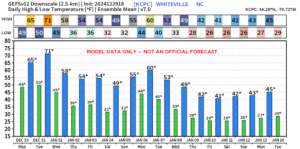
Looking at temperatures, I have attached two charts. The EPS (European ensemble mean) and the GFS ensemble mean. The Euro shows brackets that visually represent the “spread.” The green point in the center represents the average value.
The GEFS set just shows bar graphs of the average value, without any visual reference of what the spread looks like.
These charts are for Whiteville, but most other locations from Lumberton to Etown to Wilmington are similar.
The bottom line is that it is going to be unusually cold across southeast NC.
Is it going to snow???
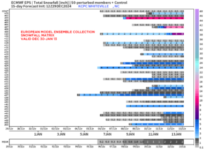
The European ensembles are also very insistent on some snowfall for the area. Attached is the snowfall matrix chart, which lists each member of the ensemble, and then looking to the right, how much accumulated snowfall that particular model thinks will occur. The very bottom shows the “mean” (average) value. Only a few of the ensembles point to anything I would deem as “significant.” Most of them point to 4 inches or less.
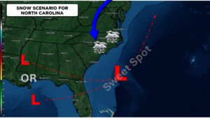
This doesn’t mean it’s going to snow. But the vast majority of the ensemble members insist on it. This will be, by far, the best opportunity that we’ve had in quite some time for accumulating snowfall locally. I’m not saying it’s going to happen. But it is definitely possible.
Conditions have to be ABSOLUTELY PERFECT for snow to fall here at all, let alone to actually accumulate. You have to have cold air firmly locked in place at all levels of the atmosphere, not just at the surface. You have to have a storm system moving to our south/east, preferably just off the coast, so no “warmth” gets thrown in.
Please don’t take seriously anyone who is posting “snowmaggedon” models showing these absurd amounts of snowfall here. It is EXTREMELY RARE for there to be a snowfall of 10+ inches locally. I’m not saying it won’t happen, but the chances are extremely, extremely low that we get some kind of “blockbuster storm.”
Let’s see how things play out. It’s definitely going to be cold, that much is fairly certain. What happens from there… it’s too soon to tell.
That’ll do it for today’s report, thanks for reading, and take care!

