Hello once again, Meteorologist Christopher Cawley here with your daily weather update for Thursday December 19, 2024.
Well our cold front is crossing the coast as I write this. We had some surprise thunderstorms over portions of the county last evening. No… it’s not going to snow in 10 days… that’s an old wives tale. The storms formed along a little ripple of instability that became established along the Robeson/Columbus/Bladen county line.
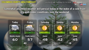
Anyway, a shallow layer of cool, moist air will be trapped on the ground today. Go a thousand feet off the ground and there’s an impressive inversion where the temperature rises quite significantly. (Normally the atmosphere cools with height from the ground — an inversion is where the atmosphere warms). This forms a “cap” and keeps lots of low clouds trapped close to the surface. Another factor in today’s weather is a weak little mid-level disturbance that will zip across NC today… and this could trigger a few passing light rain showers. I’m going with a 30-percent chance for rain today.
The clouds hang somewhat tough tonight thanks to that continued inversion in place. Go about 2,000 to 3,000 feet off the deck and temperatures rise into the 60s… while at the surface we fall into the 40s. This will keep a thick layer of cloudiness over the area along with patchy light rain / mist overnight.
The clouds should finally push out of here during the day Friday as our winds shift to the west and pick up in speed a little bit. Yet another disturbance also flits through the area, and this may trigger an isolated shower (but I doubt it). Another Arctic front pushes across the county late Friday evening … and temperatures tumble.
For the weekend, very dry air will be in place through all levels of the atmosphere. Strong high pressure will push very cold air across the area. The coldest day will be Sunday; despite full sunshine our highs will be lucky to reach the lower 40s (which is about 15-18 degrees below normal). Winds go completely calm Sunday night. Model guidance suggests that lows early Monday morning will be in the lower 20s but in my experience, that’s a bit too “warm.” Therefore, I put a low of 18 on the chart for early Monday. Whether it’s 18 or 20 or 22, it’s still going to be a very cold night Sunday night/early Monday. People, pipes, pets.
The Arctic high pushes off the coast on Monday. Temperatures rise SIGNIFICANTLY early next week… going from the mid 40s on Monday to the lower 60s on Christmas Day. The next weather system could arrive later Christmas Day or more likely Thursday the 26th as a warm, rainy storm system. Long-range temperature outlook shows that we should wrap up the year 2024 with above-normal temperatures.
That’ll do it for today, folks. Thank you for reading and supporting Columbus County News, and take care.


