Greetings folks, welcome to your CCN Daily Weather Update for Friday March 14, 2025… today is Pi Day!
This weather update is sponsored by Freedom Insurance of Whiteville. Contact Freedom today for all of your insurance needs. Their professionals are 100% committed on providing outstanding customer service and working with you to establish the best policy to meet your needs.
STATISTICS FOR WHITEVILLE – Thursday March 13, 2025.
High: 78.9°F at 1:42 PM (normal is 65)
Low: 51.4°F at 8:01 AM (normal is 40)
Precip: 0.00 in
View live, real-time weather data for Whiteville on my College Street Weather Station.
Here’s today’s Bottom Line

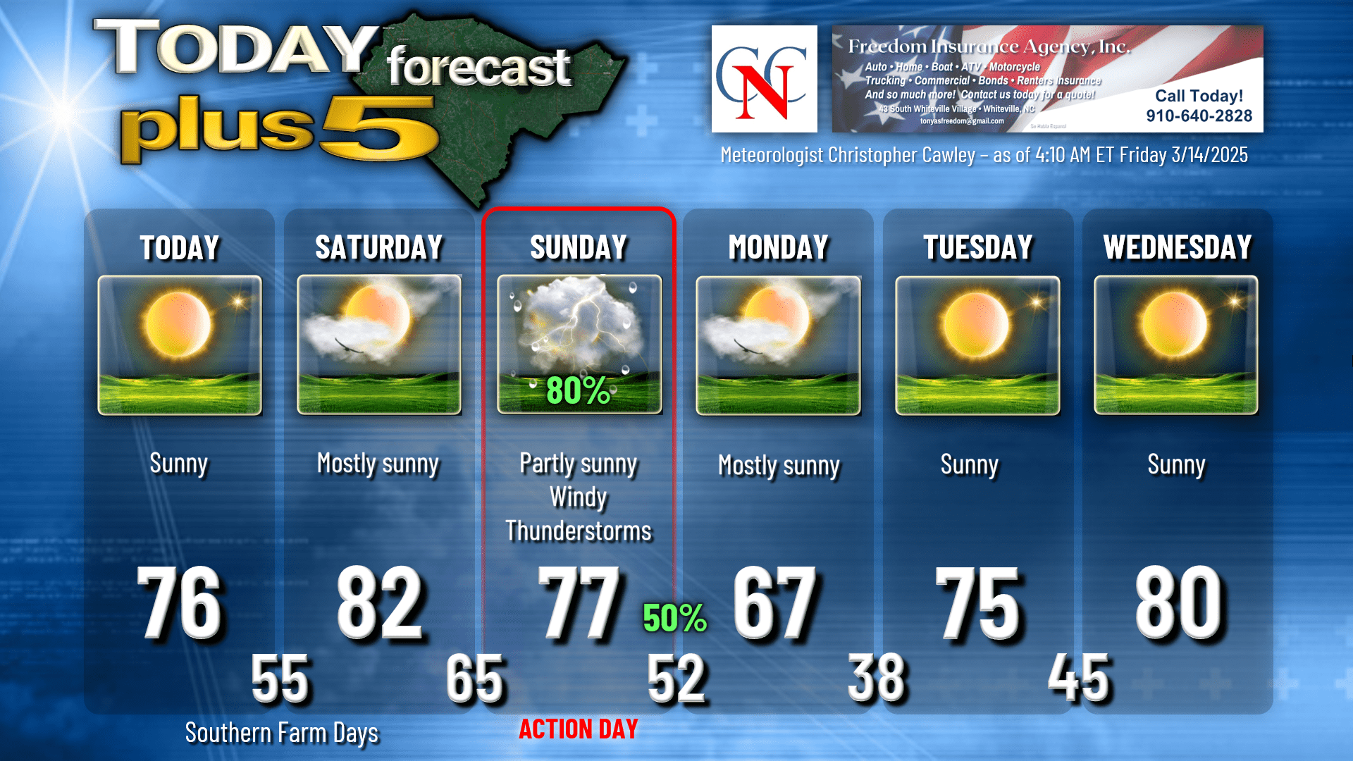
A little bit of a backdoor cold front has dropped down from the north. This really won’t mean much to anyone other than it’s going to knock our forecast highs down a couple of degrees. There will be a light easterly wind which means if you’re headed to places like Wilmington, Carolina Beach, Topsail, etc., the temperature is going to run a good 10-12 degrees cooler than they will be here. For Columbus County, highs will generally be in the mid 70s… but again, head toward those east-facing beaches, and they’ll be lucky to see highs in the mid 60s (which is actually “normal” for this time of year).
The front lifts north later this afternoon as a warm front. This will shift our air flow from the east to the south, and much more moisture will be lifting northward tonight. I expect some areas of fairly dense fog overnight.
That fog will give way to bright sunshine and warm temps for your Saturday. It will become increasingly breezy during the afternoon as well. Highs will be in the lower 80s.
SOUTHERN FARM DAYS FORECAST: We hope to see y’all out at Lake Waccamaw for Southern Farm Days. There will be zero weather worries for today and Saturday, and I’ll be there at 10 AM on Saturday. As for Sunday…. well it’s probably best that you go out today or Saturday.
SEVERE RISK FOR SUNDAY: For a couple of days now I’ve been talking about the potential for some strong thunderstorms on Sunday. What is certain at this time is that a strong cold front will cross the area late Sunday. There will be a robust low-level jet and wind shear values will be quite impressive. A line, or a broken line, of convective activity (showers and thunderstorms) will cross the area at some point on Sunday. That’s the end of the certainties.
Sunday will be windy and warm and generally cloudy. This robust southerly flow will push ocean air inland, well inland, possibly as far inland as the I-95 corridor. This marine layer will be the key as to whether or not we receive any severe weather in Columbus County. The last event, the marine layer really put a lid on the whole operation, keeping the instability and the stronger winds higher up in the atmosphere (the marine air layer is cooler and stable, and therefore resides closer to the Earth’s surface). Last week’s marine layer was actually relatively thin. I think this one on Sunday is likely to be a bit more emphatic.
The Storm Prediction Center still has all of eastern NC and SC outlined under a level 2 out of 5 risk for Sunday, but honestly I think the better likelihood for severe weather is west of the 95. We still have some time to watch how things unfold with the modeling, but my gut instinct is that the marine layer is going to win out. Should that be the case, we can expect showers and thunderstorms from mid- to late-morning Sunday through the afternoon and evening, and while we could see some winds in the 30-40 mph range, I think any damaging wind threat will be very isolated.
The NBM rainfall chart has the county picking up around an inch of rain from this system Sunday into Sunday night. That’s a good outcome. Go to church on Sunday, and then go home… take a nice nap. That’s my plan.
As for next week, all guidance suggests that after the upper-level trough moves off the coast on Monday, we’re high and dry for much of next week. St. Patrick’s Day will feature temperatures actually right where they should be this time of year… but that doesn’t last long as we warm back up into temps that would be more typical of late-April rather than mid-March.
Is it REALLY spring??? Can I go ahead and do my planting?? In looking at ALL of the longer-range modeling, there is only one morning (March 21st) between now and the end of the month where there’s a small concern for frost. For the morning of the 21st, the lowest ensemble reading is 35 degrees. Outside of that, there is near-zero frost/freeze threat through the end of the month. I’m not your papa… I’m not going to tell you what to do with regards to planting. Temperature model charts through the end of the month tell us we’re good to go. The rest is up to you.
Here is your Freedom Insurance Today-plus-Five forecast for Columbus County.
That will conclude today’s report, my friends. Thank you for your time, thank you for supporting CCN, and thank you to Freedom Insurance for sponsoring our daily reports. I hope you have a wonderful day, and as always, take care.
~Meteorologist Christopher Cawley