
Greetings friends and followers, welcome to the Wednesday edition of the CCN Weather Update.
GAME TIME.
This weather update is brought to you by our friends at Freedom Insurance in Whiteville. When severe weather strikes, have the peace of mind that your vehicles and property are well covered. Visit our office for comprehensive policy quote that will fit all of your needs. Call us at 910-640-2828 or stop in at the south end Hills shopping plaza.
Here’s your Bottom Line for today…
Windy and warm today. With our area firmly in the warm sector ahead of a massive cold front, the low-level jet continues to strengthen. This jet wind will be AT LEAST 50-60 mph only 1,500 feet off the deck. Oftentimes in situations like these, the southerly flow pushes the marine air layer (colder, stable air from the ocean) much farther inland, over Columbus County. That marine air layer acts as a protective blanket.
Except today. The marine layer is likely to be very thin… unusually so for this time of year. Therefore, we have a much better chance for higher winds here at the surface … wind gusts of 40-50 mph are possible on the ground. Oh… that doesn’t include the line of storms.
The aforementioned cold front pushes across the area this evening. Another reinforcing (but weaker) front pushes in closely behind it during the overnight tonight.
But you don’t care about those details, you want to know about the storms. Ok… here we go.
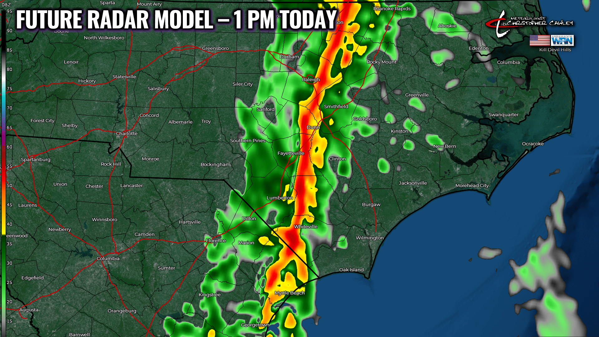
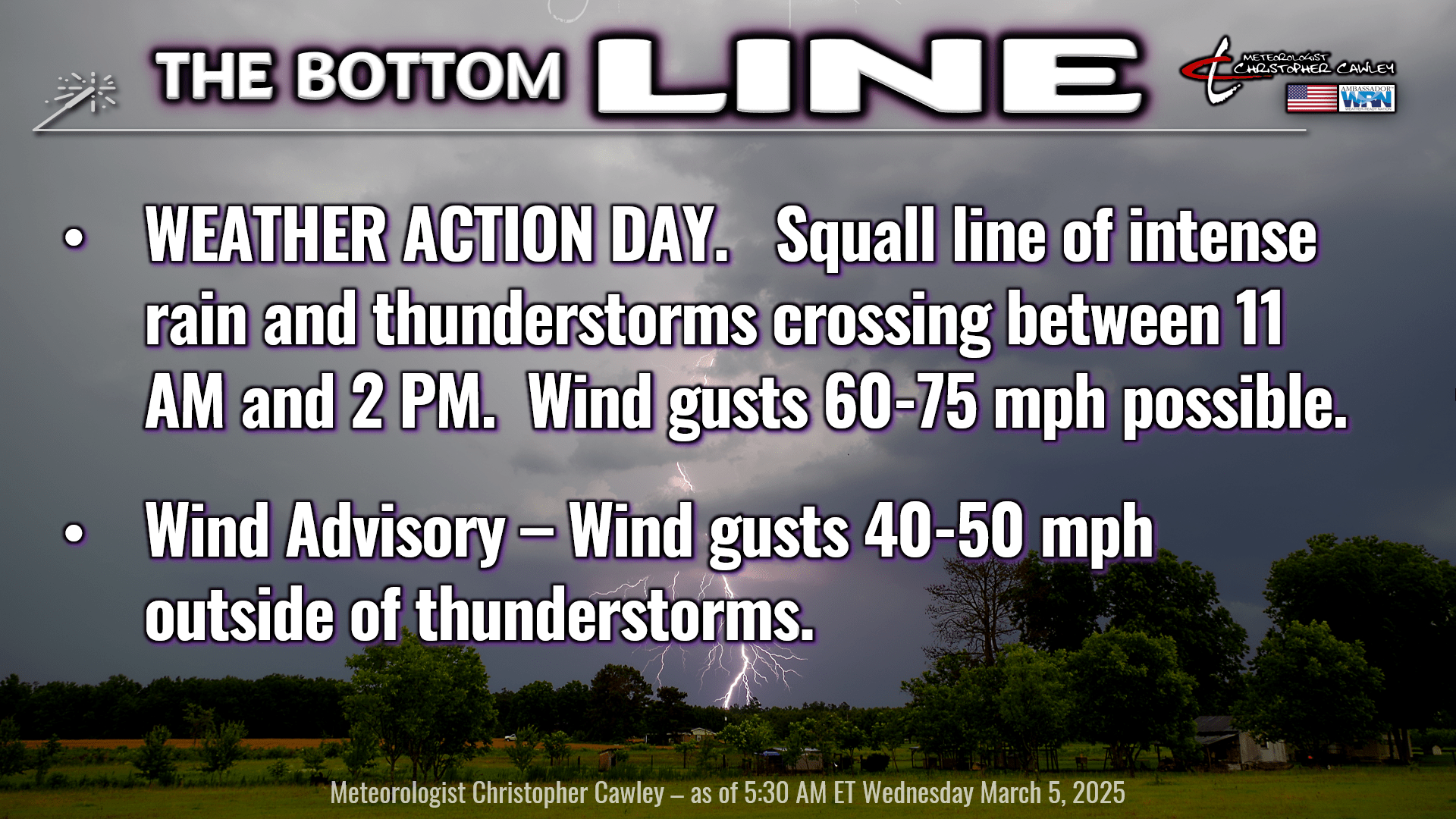
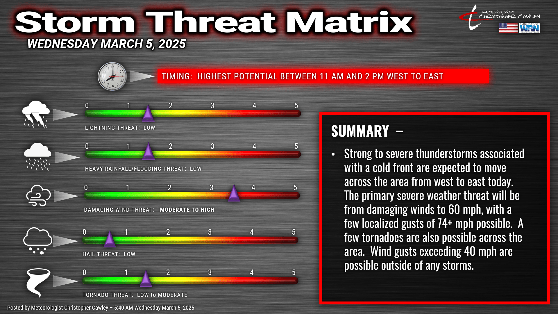
A significant line of showers and thunderstorms will move west to east over the area, late this morning into early this afternoon (for Columbus County, the window is from roughly 11 AM to 2 PM).
SCIENCE ALERT!
Kinematics (air motion in a “piece” or column of atmosphere) are rather eye-popping. If you’re a weather nerd and want details, ensemble members of the latest HREF modeling (a product of NWS) show storm relative helicity values in the lowest levels of the atmosphere are within the 300-400 m/s2 (meters per second-squared) range. What does this mean? Storm relative helicity is a measurement of wind shear that can indicate the likelihood of tornadoes. SRH values greater than 250 m/s2 may indicate an increased tornado threat.
Next, bulk shear values are in the 70-85 mph range, while speeds in the lowest levels try to push past 65 mph.
And finally, the instability… which has been the question-mark this whole time… is starting to look pretty good, especially for an early March event.
(That’s the end of the “Science section.”)
All of this sets the stage for a true-blue severe weather event today.
The NWS Storm Prediction Center has our area in a level 3 out of 5 for storm threat, and when looking at the wind profile, they have listed our area as having a 30% to 44% probability of damaging winds, with an additional 10% probability of significant wind gusts of 74 mph or greater. I know 10% doesn’t sound like much, but that’s actually quite significant.
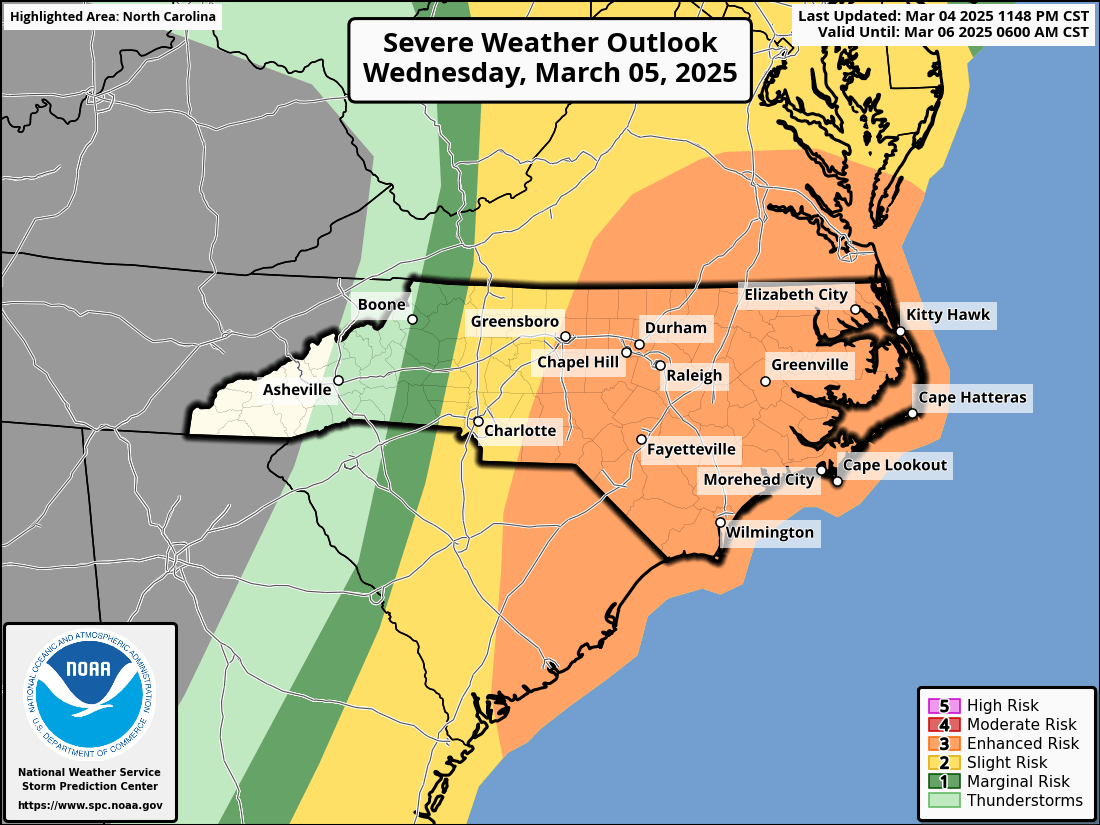

But wait… there’s more! Isolated tornadoes are a threat today, especially with the increased SRH values.

It is PARAMOUNT that you have multiple ways of getting alerts and warnings. I will do my best to keep up on my FB page (@Meteorologist Christopher Cawley) during the event, as long as the power stays on.
Downloading the FEMA app for free on all Apple and Android devices will allow you to get push notifications of all watches and warnings that are issued.
A severe weather WATCH means that conditions are FAVORABLE for the development of severe weather. It does not mean that it’s a guarantee to occur.
A severe weather WARNING means that severe weather is occurring or is imminent, and immediate action should be taken to protect life and property.
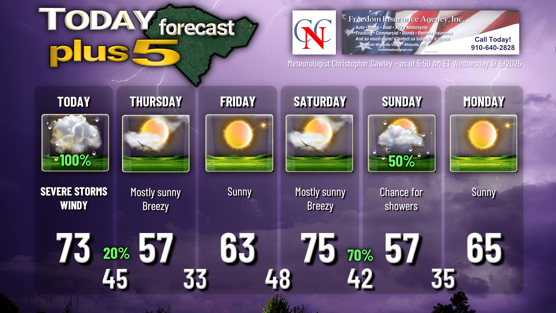
The rest of our forecast is quiet until the next frontal boundary Saturday night into Sunday. Today’s focus is entirely on the severe weather event.
Here’s your Freedom Insurance Today-Plus-5 forecast for Columbus County.
That’ll do it for today. STAY WEATHER AWARE TODAY.
~Meteorologist Christopher Cawley