Good Monday evening, Meteorologist Christopher Cawley here with an update on Milton. While impacts for the Whiteville area will be essentially nil, the same cannot be said for our friends in Florida.
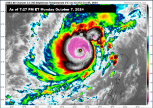
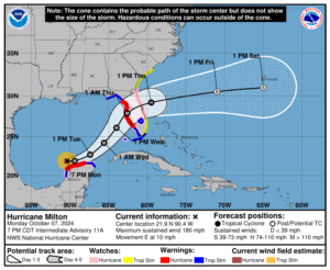
As of 8 PM Monday, Milton has maximum sustained winds of 180 mph with higher gusts, and a central pressure of 897 millibars… Milton is one of the strongest hurricanes in the Atlantic basin — ever.
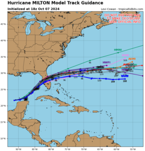
All indications put Tampa, FL in the crosshairs for a landfall Wednesday evening. The good news is that Milton should “weaken” and “only” be a high-end cat-3 at landfall. In all seriousness, this will be devastating: The landfall will be accompanied by 125-135 mph winds in the eyewall, along with a 10- to 15-foot storm surge tsunami, with 5-10 foot surge from Yankeetown, FL, southward to Bonita Beach.
This is going to be catastrophic to the Tampa/St. Pete area. I do hope and pray people heed the evacuation orders. My words are not “hype” or hyperbole. Some of the barrier islands on the west coast of Florida were heavily impacted by Helene and are still trying to clean up from that. This will be a knockout blow.
As for local impacts across eastern North Carolina, again, little if anything for Columbus County. At the beaches, there will be rough surf and significant rip currents. The cold front passing through our area this evening will help keep Milton pinned to our south. There may be some rogue rain showers as far north as the Myrtle Beach area, maybe the beaches of Brunswick County. Breezy conditions can be expected Wednesday night and Thursday for areas south of US-74/76. Outside of that, I don’t expect any significant impacts locally. If Milton tracks a little farther to the north, that could push some rain showers into Columbus County, but as of 8 PM Monday that doesn’t appear to be the case. Our weather should remain quiet and seasonable through Thursday before temps turn above normal again for Friday through the weekend.
Next update on here will be Tuesday evening. As always, you can get RELIABLE storm updates from the National Hurricane Center.