Greetings friends and followers. It’s time for the CCN Daily Weather Update for Wednesday February 26, 2025.
This weather update is brought to you by our friends at Freedom Insurance in Whiteville. For car, home, or future, Freedom Insurance has your back. Stop in or give them a call at 910-640-2828 and their professionals will put together the best policy for you!
STATISTICS FOR WHITEVILLE – Tuesday February 25, 2025.
High: 74.8°F at 3:23 PM (normal is 60)
Low: 37.3°F at 7:00 AM (normal is 35)
Precip: 0.00 in
View live, real-time weather data for Whiteville on my College Street Weather Station.
Here’s your Bottom Line for today…
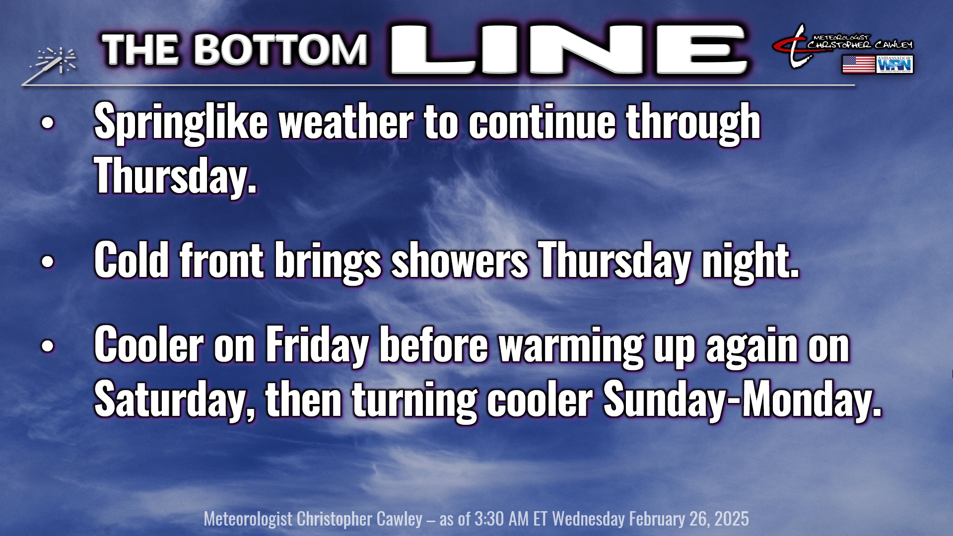
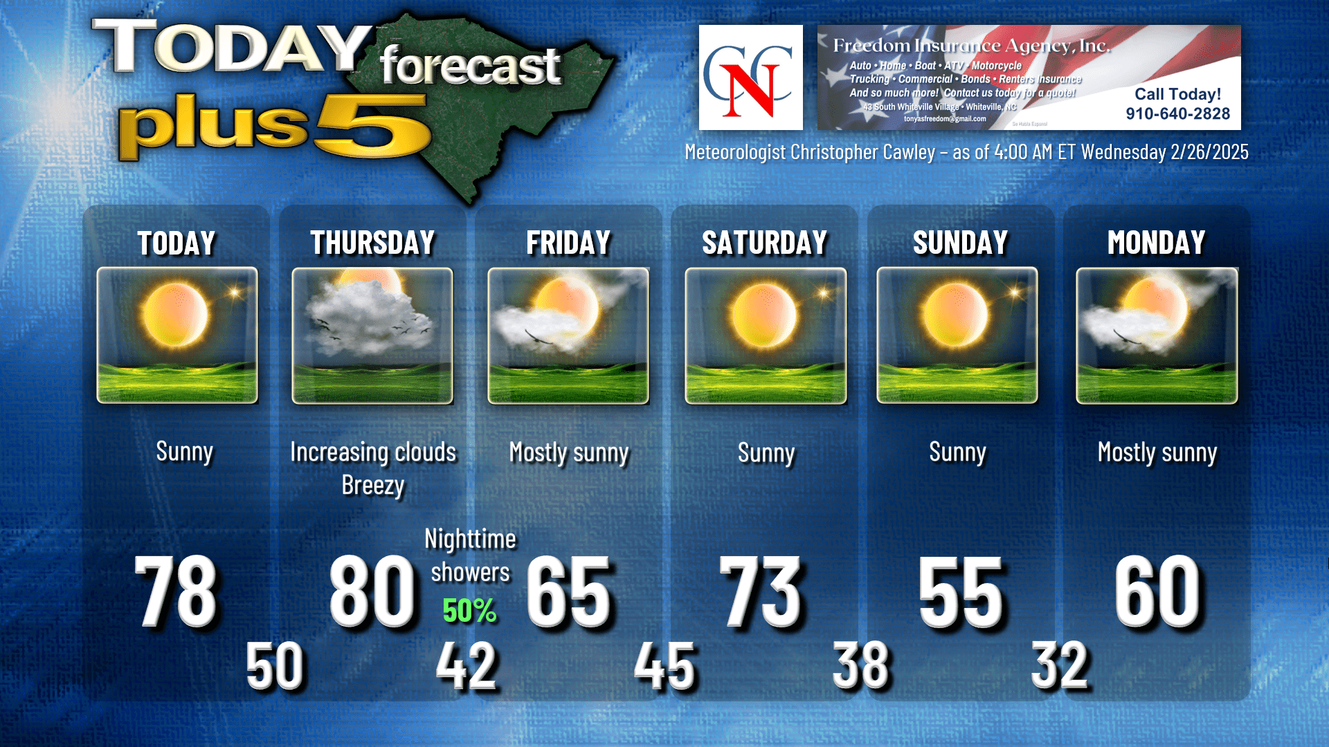
Ridging high pressure overhead today brings lots and lots of sunshine and warm temperatures. I believe we’ll jump into the mid and upper 70s… I put “78” on the graphic for this afternoon. Southerly breezes start to develop this afternoon which will help push those temps up.
Our skies will be clear tonight with springlike lows around 50.
The much-talked-about cold front pushes toward the area on Thursday. We’ll see increasing cloudiness throughout the day, but gusty southwest breezes will push our highs to near 80 across the county. If you’re headed toward Wilmington or Southport or Shallotte, however, highs will be stuck in the upper 60s to mid 70s thanks to the ocean.
Anyway, the front is expected to push across the area during the evening hours. A broken/segmented line of showers is likely to accompany the front. At this time I don’t think we’ll see any thunder, in spite of the strength of the frontal boundary. Since it’s an evening/night frontal passage, there simply isn’t any instability to work with. I’m going with a 50/50 chance with showers… it’s possible some spots don’t pick up any rain at all.
Temps turn colder during the overnight/pre-dawn on Friday, and our lows should drop to the lower 40s.
High pressure builds in on Friday. It’ll be much cooler … but still above normal … with highs reaching the mid 60s with sunny skies.
Southerly flow picks up again Friday night into Saturday ahead of a couple of dry cold fronts that push through Saturday night and on Sunday. We should easily get into the 70s on Friday but then front #1 crashes the party Saturday night, dropping our temps into the upper 30s, and front #2 quickly follows on Sunday. While we have lots of sunshine on tap for Sunday, our highs will be in the mid 50s at best (and that’s on the higher end of the NBM latest cycle). We drop down to the freezing mark by early Monday morning, and some of the typically colder spots may drop down to around 30 by school bus ride time. We’ll rebound to around 60 on Monday with more sunshine.
Longer term trends show a very strong cold front lurking in our future for NEXT week. This could be our first severe weather threat of the spring season, with guidance generally targeting the Wednesday-Friday timeframe (March 5-7). The latest European is much more aggressive than the GFS, which is a bit of a flip-flop from yesterday’s information. So we’ll be in the “watchful waiting” cycle of things.
If we get severe weather next week, that’ll be perfect because the week of March 2-8 is Severe Weather Awareness week across the Carolinas. I will be producing a series of videos on my Youtube channel about severe weather in the Carolinas.
Finally, if you’re sniffling and sneezing, it could simply be the Carolina Crud, but it also could be the increasing pollen counts across the county. According to pollen.com, we have a pollen count today of 9.3, with top allergens being Elm, Juniper, and Alder. Thursday’s pollen count will be over 10 ahead of the frontal boundary. Welcome to almost-spring!
Here’s your Freedom Insurance Today-Plus-5 forecast for Columbus County.
That’ll do it for today. Thanks for reading, and as always, take care!
~Meteorologist Christopher Cawley