Greetings folks, welcome to the Saturday edition of the CCN Weather Update. Lots to cover today!
This weather update is brought to you by our friends at Freedom Insurance in Whiteville. When severe weather strikes, have the peace of mind that your vehicles and property are well covered. Stop in today for a comprehensive policy quote that will fit all of your needs. Call us at 910-640-2828 or stop in at the south end Hills shopping plaza.
STATISTICS FOR WHITEVILLE – Friday February 28, 2025.
High: 71.4°F at 3:23 PM (normal is 61)
Low: 40.6°F at 6:48 AM (normal is 36)
Precip: 0.00 in
View live, real-time weather data for Whiteville on my College Street Weather Station.
Here’s your Bottom Line for today…
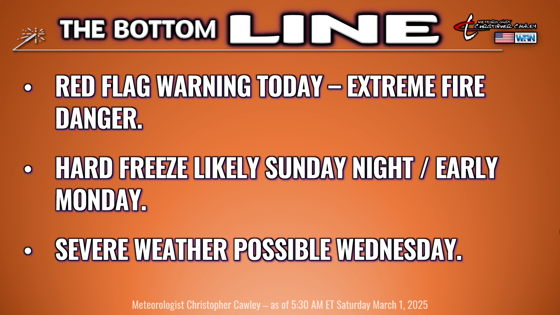
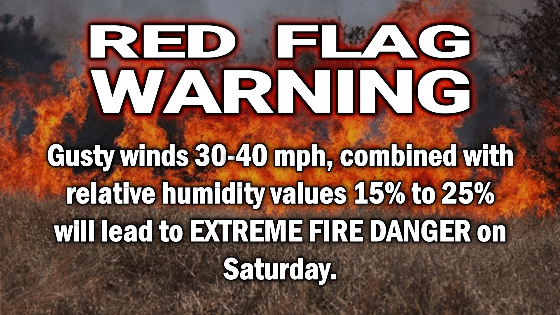
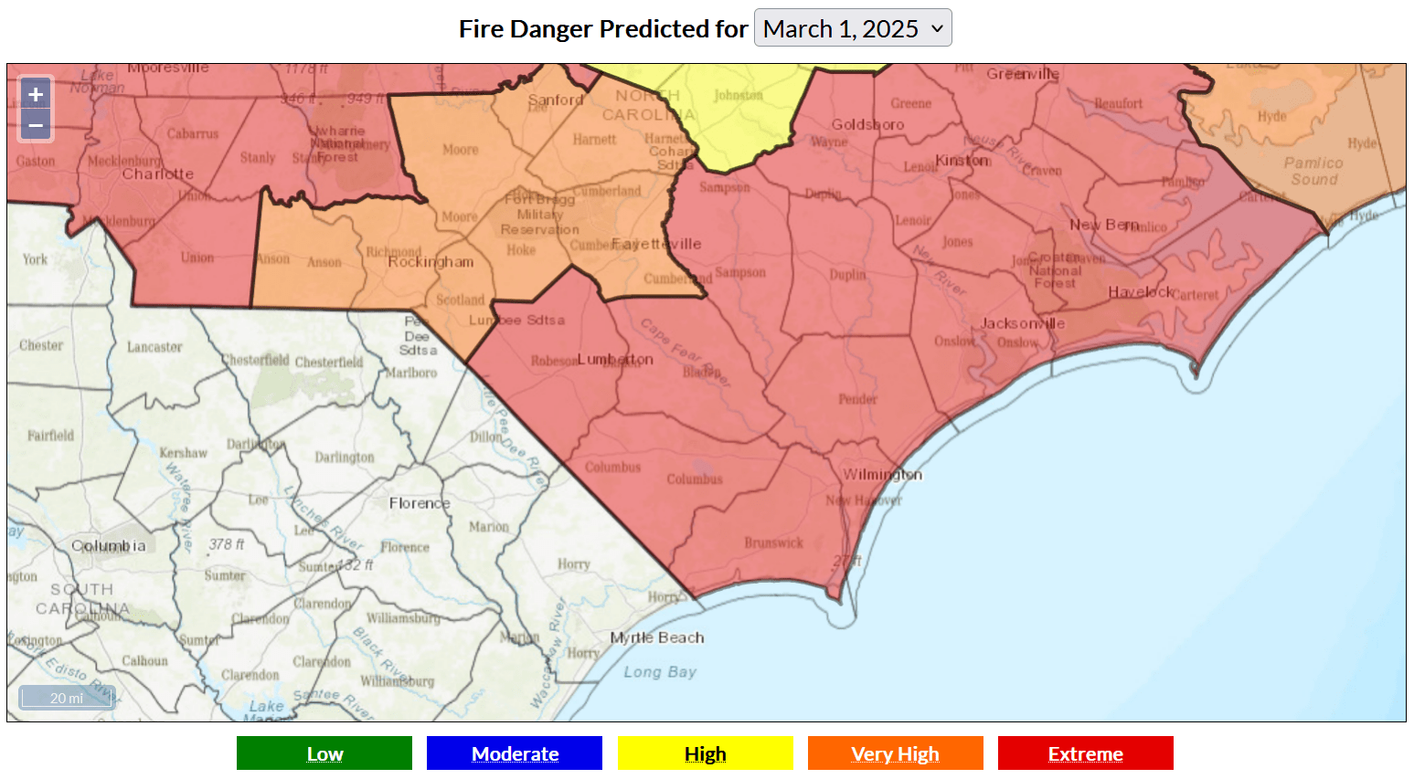
EXTREME FIRE DANGER FOR TODAY.
DO NOT BURN!
High pressure over central Florida, combined with very deep low pressure over the St. Lawrence along the USA/Canada border, with a cold front in between… will all lead to a very gusty day today.
Strong southwest winds may gust 30-40 mph from late this morning until the cold front blasts through during the evening hours.
The frontal passage will be completely dry. Moisture from the surface to about 5,000 feet is desert-like, and we will experience relative humidity values as low as 15% in some places this afternoon. That is RARE for the coastal Carolinas and will only amplify our already critical fire conditions.
I’m not really sure how much more clear I can be with this: Do not burn! Don’t do it! That field or that ditch can wait until another day.
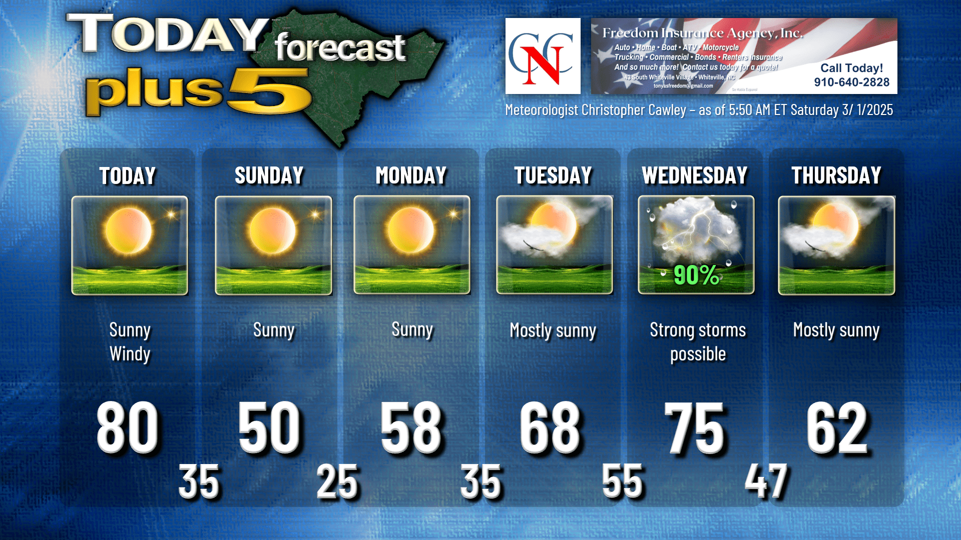
As I said, the front pushes through tonight with some scattered clouds early this evening and an abrupt wind shift during the late-evening hours. Temperatures absolutely CRASH behind the frontal passage, and we’ll wake up to readings in the mid 30s Sunday morning.
North winds finally relax a little bit on Sunday but a deep Canadian air mass will be overhead. Despite full sunshine (which on March 2nd is equivalent to October 2nd), our highs will struggle to reach the 50-degree mark.
Calm winds and clear skies with high pressure overhead Sunday night means we go low, go low, go low into a deep, hard freeze. Bus-stop temps on Monday morning will be in the mid to upper 20s across the county… possibly approaching record territory.
Monday will be sunny with temperatures a bit closer to normal, but still coming up a little bit short… in the upper 50s.
Tuesday will feature a mix of sunshine and clouds as a robust southerly flow becomes established. Temperatures jump a good 10-13 degrees from their Monday highs. Meanwhile, a dynamic storm system will be getting it’s act together over the central plains. The main low will lift northeastward over the Great Lakes going into Wednesday, and this will lift a warm front over the area early Wednesday morning. I believe we’ll see lots of clouds around Tuesday night and maybe a shower or thunderstorm early Wednesday with the warm front.
SEVERE WEATHER THREAT ON WEDNESDAY
A powerful cold front will take aim on ColCo Wednesday. At this time the guidance is suggesting that the front moves through during the late afternoon or early evening. There is likely to be a profound low-level jet reaching 70+ mph at about the 5,000 foot level, resulting in gusty surface winds throughout the day. A line of convection ahead of the front will push from west to east Wednesday afternoon. Of the three ingredients for severe weather, only the instability level is still up for some debate. If we break out into some sunshine on Wednesday, and if the convective line moves through at just the right time, an organized severe weather event (featuring damaging to destructive straight-line winds) would be the outcome. We’re still several days out, though, so there’s some time to fine tune all of this.
After that clears out, our weather clears and temps return to seasonable normal values into next weekend.
Severe Weather Awareness week begins Sunday, and I will be posting a series of videos on my Youtube channel and my socials talking about severe weather in the Carolinas. The 2025 Statewide Tornado Drill is scheduled for 9:30 AM on Wednesday March 5th.
Here’s your Freedom Insurance Today-Plus-5 forecast for Columbus County.
That’ll do it for today. DON’T BURN!! Thanks for reading, and as always, take care!
~Meteorologist Christopher Cawley