Courtesy National Weather Service
The only tropical system to directly strike the continental United States this year was Tropical Storm Chantal – which hit North Carolina and caused flooding in some areas.
The first Category Five of the busy season, Hurricane Erin, brushed the Outer Banks, but did not make a direct landfall on North Carolina. Erin was also one of the fastest moving systems on record.
All in all, the 2025 Atlantic hurricane season, which officially ends on Nov. 30, was notable for its striking contrast — wavering between periods of relative calm and bursts of intense activity, generating very powerful storms. Overall, the season fell within the predicted ranges for named storms, hurricanes, and major hurricanes issued in NOAA’s seasonal outlooks.
“For the first time in a decade, not a single hurricane struck the U.S. this season, and that was a much needed break,” said Neil Jacobs, Ph.D., NOAA administrator. “Still, a tropical storm (Chantal) caused damage and casualties in the Carolinas, distant hurricanes created rough ocean waters that caused property damage along the East Coast, and neighboring countries experienced direct hits from hurricanes.”
“The 2025 season was the first year NOAA’s National Hurricane Center incorporated Artificial Intelligence model guidance into their forecasts,” added Jacobs. “The NHC performed exceedingly well when it came to forecasting rapid intensification for some of the more impactful storms and provided critical decision support for our Caribbean partners.”
The Atlantic basin produced 13 named storms (winds of 39 mph or greater), of which five became hurricanes (winds of 74 mph or greater), including four major hurricanes with winds reaching 111 mph or greater. An average season has 14 named storms, seven hurricanes, and three major hurricanes.
“Throughout the hurricane season, and all year long, the National Weather Service works around the clock to meet our mission of saving lives, protecting property and enhancing the national economy,” said Ken Graham, director of NOAA’s National Weather Service. “I’m grateful to this talented team for their steadfast dedication to the safety of the American public.”
While the climatological peak of the hurricane season was quiet with no tropical activity, the season generated three Category 5 hurricanes, the second-most on record in a single season. “Fortunately, short-term weather patterns largely steered tropical systems away from the United States,” Graham added.
Atlantic Basin: Key Storms and Statistics
Tropical Storm Andrea formed on June 23, kicking off the season. Tropical storms Barry and Chantal then developed in rapid succession, before activity took a pause. Chantal was the only storm to make landfall in the U.S., bringing excessive rainfall and flooding to North Carolina.
Hurricane Erin was the first Category 5 storm of the season and brought storm surge and tropical storm conditions to the North Carolina Outer Banks and rough surf and rip currents along the East Coast. Erin underwent rapid intensification, and is tied for the fifth-fastest 24-hour increase in maximum sustained winds on record, from 75 mph to 160 mph. Erin also tied for the third-fastest 24-hour pressure drop in the Atlantic basin on record, dropping 83 millibars from 998 mb to 915 mb.
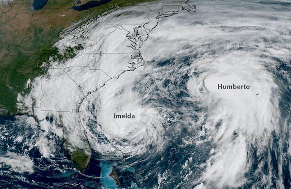
Hurricane Humberto became the second Category 5 hurricane, and soon after, Hurricane Imelda developed and became the final storm of September.
Hurricane Melissa developed into the third Category 5 hurricane of the season, and became one of the strongest Atlantic basin hurricane landfalls on record when it made landfall in southwestern Jamaica on Oct. 28, bringing extensive damage to Jamaica, Hispaniola, and eastern Cuba. Melissa was the fourth storm to undergo rapid intensification this year, with a 115-mph wind increase and a 90 millibar decrease in central pressure in a 72-hour period ending at 11 a.m. EDT on Oct. 28.
Four days before Melissa’s landfall in Jamaica, the NHC projected a path over western Jamaica, a forecast that ended up with a track difference of only about 13 miles.
“NHC’s intensity forecasts for Melissa outperformed every model at nearly every lead time and provided almost three days of advance notice that Melissa would make landfall in Jamaica as a powerful Category 5 hurricane,” said Michael Brennan, Ph.D., director, NOAA’s National Hurricane Center. “This lead time was remarkable because it was the first time NHC forecasted a hurricane to reach Category 5 intensity from such a low initial intensity when the forecast was first issued.”