Greetings friends, happy Valentine’s Day! Here’s your Friday CCN Weather Update!
Your CCN Weather Update is sponsored by Freedom Insurance in Whiteville. If you need a policy for that sweet new Ram truck, they’ve got you covered. If you need a policy for the home you’re planning to purchase, they’ve got you covered. Contact them today at 910-640-2828 or stop in, and the Freedom Insurance representatives will work with you to write the best policy for your needs.
STATISTICS FOR WHITEVILLE – Thursday February 12, 2025.
High: 69.6°F at 2:29 PM (normal is 57)
Low: 44.4°F at 12:02 AM (normal is 33)
Precip: 0.36 in
View live, real-time weather data for Whiteville on my College Street Weather Station.
Here’s your Bottom Line for today…
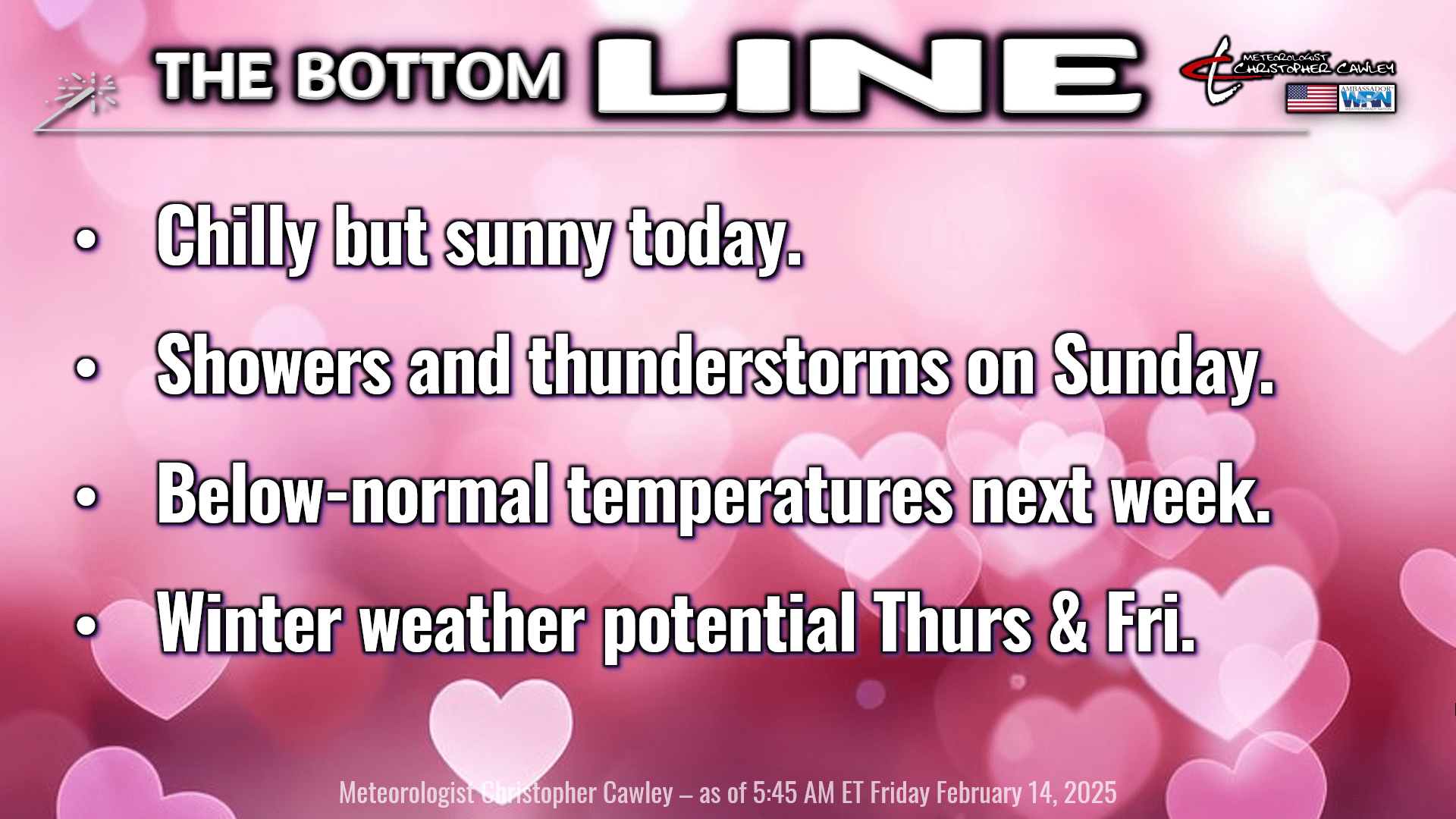
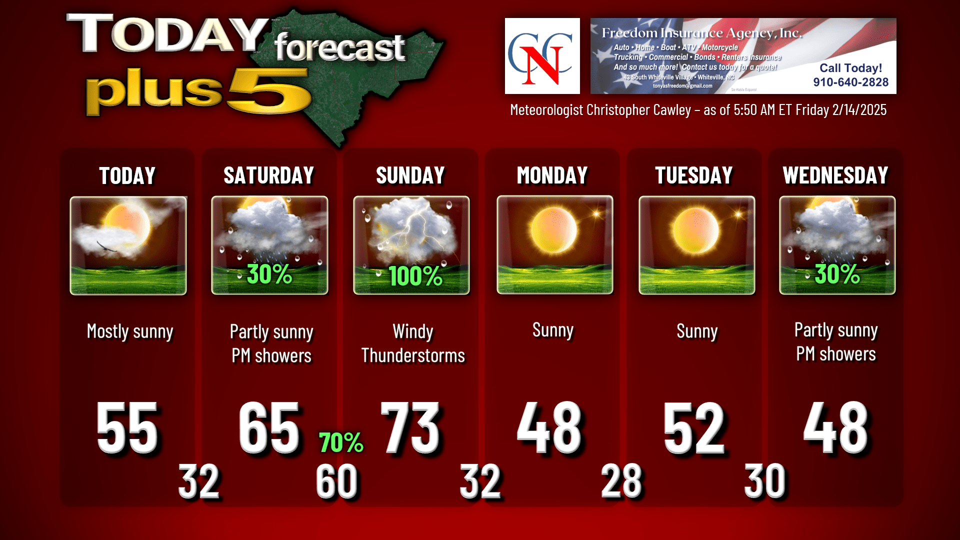
There’s a big, bright yellow orb in the sky today… for those unfamiliar, that’s the sun! We’ll have a bright sunny day across the county but our temps will be a touch below normal. We’ll max out in the lower to middle 50s. We remain clear for tonight, our lows dropping to the lower and middle 30s. Areas of frost are likely tonight, and some spots out of town could possibly drop as low as 30.
For Saturday, a warm front will lift slowly from southeast to northwest throughout the day. The high temperature forecast is very tricky because areas west/north of the front will be cold (40s and 50s), whereas areas south/east of the front will punch into the upper 60s and lower 70s. The various assortment of short-term models seem to have a little bit of agreement that the front does clear the county during the afternoon. The NBM (National Blend of Models) puts highs generally in the mid 60s on Saturday, so I’ll go with that — just with the caveat that we might not see those temps until later in the afternoon.
Scattered showers are possible Saturday afternoon in the wake of the warm front. Not a washout, but keep that in mind if you have any plans for Saturday.
You can expect scattered showers Saturday night as we will have an increasing south/southwest flow. Winds will also pick up during the evening. This S/SW flow brings abundant moisture into the area — guidance shows that precipitable water values reach values that one would expect in mid-May, rather than mid-February. (Side note, precipitable water is the measure of depth of liquid water at the surface that would result if you “rained out” all of the water vapor in a particular “section” of the atmosphere.) Anyway, all of this moisture lifting into the area on a strong low-level jet means that rain is all but certain to occur. Temperatures won’t drop much Saturday night; we’ll probably stay above 60 throughout the night.
Sunday is the culmination of this particular sequence of events, and I’ll probably list this as a “weather alert day.” Strong low-level jet continues early in the day; gusty south to southwest winds will dominate the morning. A convective line well ahead of the actual cold front should move across the area around lunchtime into the early afternoon. Modeling is in remarkable agreement on the timing of this. The low-level jet increases to over 70 knots ahead of this line (about 80 mph), so gusty winds are likely just ahead of the line. We will have lots of cloud cover throughout the morning on Sunday, so I don’t think there’ll be much in the way of instability, and our proximity to the ocean means a stable (cold) marine air layer may exist over the eastern third of the county. While we may have some thunder with the convective line, I don’t think we’ll see any severe weather.
The convective line should be moving relatively quickly. Expect a brief burst of intense rainfall, followed by a diminishing in intensity to nothing after about an hour or so.
Those who know me know that I VERY RARELY put a “100%” label on a graphic. Sunday is an exception to that rule.

We should break out into sunshine after the convective line passes through. Our highs on Sunday should reach the lower 70s.
The cold front itself moves through Sunday evening with rapidly clearing skies behind it and cold air absolutely pouring into the area from the west. Temperatures will go well below normal early next week as high pressure ridges across the area Monday into Tuesday. Low temperatures dip into the upper 20s Monday night… possibly mid 20s in outlying areas… and around 30 on Tuesday night.
….then things get interesting.
As it stands right now, deterministic modeling (all three – the GFS, Euro, and Canadian) agree that low pressure develops on the southern jet stream, moves along the northern Gulf coast, turns the corner, and lifts up the GA/SC/NC coast. The devil in the details is the location of the low, how much cold air pushes in from the north/west, and the storm track.
The overall evolution of the storm system is quite similar to that of our January snowstorm. The key difference is we probably won’t have such a deep, cold air mass in place. There is also great uncertainty on the storm track. In January, we threaded the needle perfectly, and that’s rare. I don’t know what our Vegas odds are on that happening a second time in one season.
The NWS seems to believe that the best chances for wintry precipitation are farther to our north and west, as illustrated on this graphic.
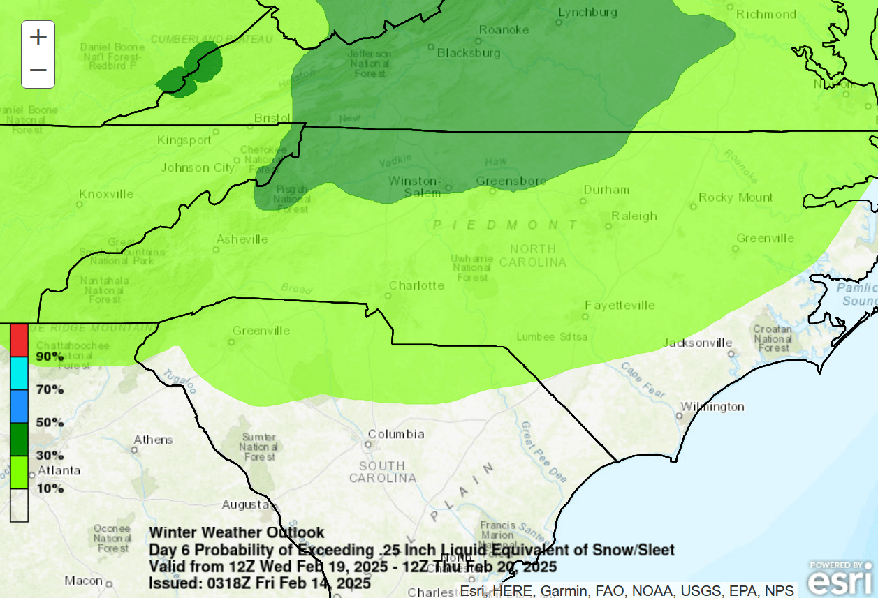
This gives areas north and west of a line from roughly Rowland through Elizabethtown through Burgaw 10% to 30% probability of frozen precip, while our friends much farther to the north and west have a 30% to 50% probability. But remember, we’re 6-7 days out. It’s way too soon to make a call … and all precipitation types are in play. Even the three deterministic models don’t agree (as of right now) — Euro says rain, GFS says rain-to-ice-to-snow, Canadian says mix-to-rain.
A glance at ensembles shows 22 out of 82 members (27%) with accumulating snow (greater than 0.1 inch). Take that however you choose, but remember, we’re a week out.
Here’s your Freedom Insurance Today-Plus-5 forecast for Columbus County.
And with that, we come to the conclusion of another CCN Weather Update. I want to give a sincere thanks for reading and sharing. If you ever have any weather-related or forecast-related questions, don’t hesitate to reach out to me on my socials. Happy Valentine’s Day, and as always, take care.
~Meteorologist Christopher Cawley