Rainy days this Monday… greetings and welcome to the CCN Daily Weather Update!
Today’s weather update is brought to you by our friends at Freedom Insurance in Whiteville. When accidents happen, and they will, our friends at Freedom Insurance can make sure you are fully covered for whatever life throws at you. Give them a call today at 910-640-2828 and the experts at Freedom will make sure everything is perfect for you.
STATISTICS FOR WHITEVILLE – Sunday March 9, 2025.
High: 61.9°F at 2:47 PM (normal is 64)
Low: 46.8°F at 8:19 AM (normal is 39)
Precip: 0.00 in
View live, real-time weather data for Whiteville on my College Street Weather Station.
Here’s your Bottom Line for today…
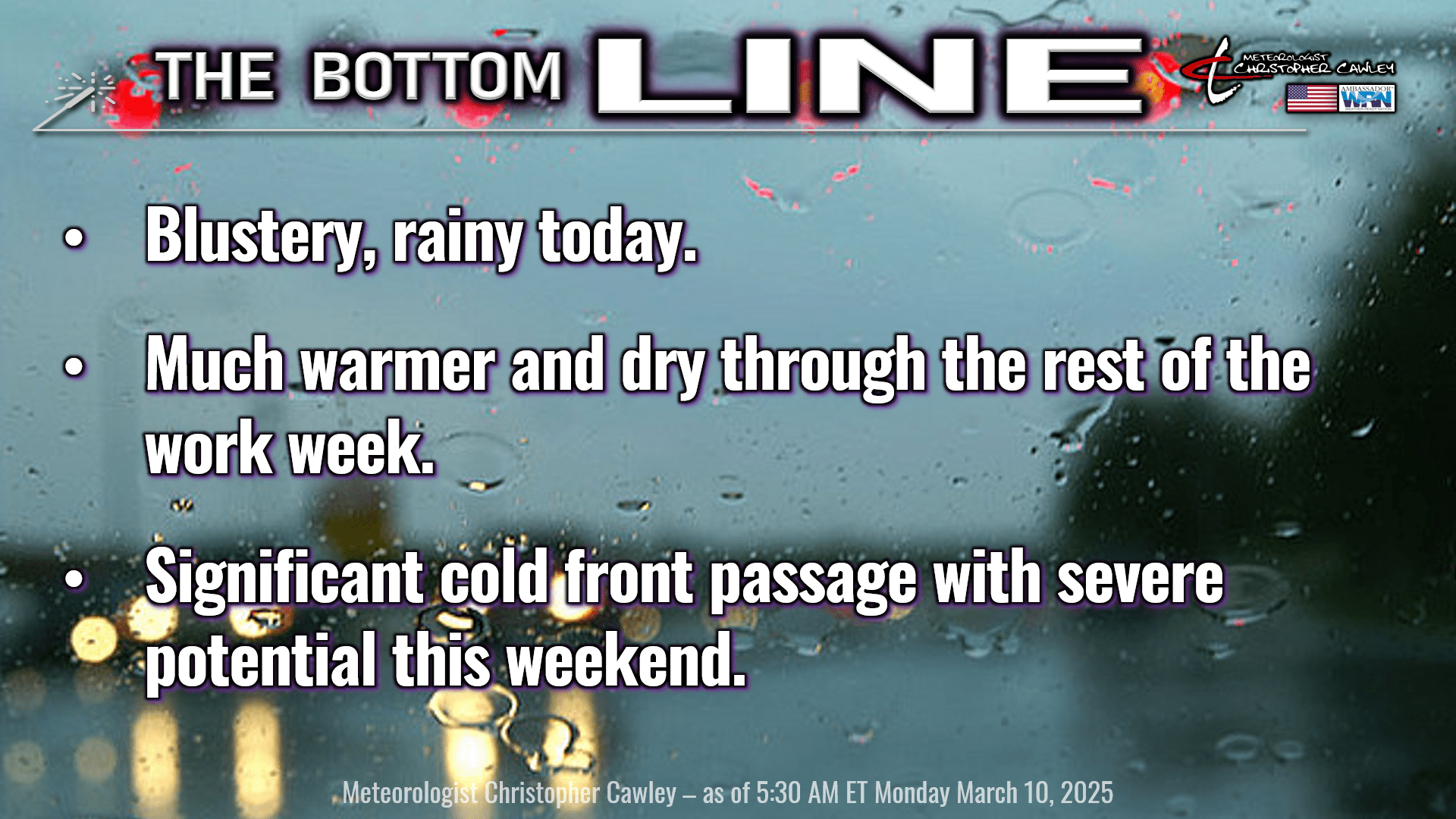
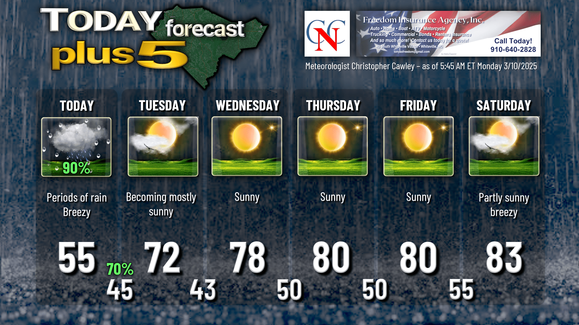
Low pressure will move through southern Georgia and South Carolina, to a position off the coast by this evening. This will bring periods of rain to the area today… and the rain may be heavy at times this afternoon and this evening. We may also have some rumbles of thunder depending on how close the storm center tracks to the state line.
Model blends are still honing in on around an inch of rain across the county through tonight… liquid gold for the dry conditions, but this isn’t going to be a drought-buster.
You will want to be a little careful if you’re traveling this afternoon. Watch for ponding of water on roadways and gusty winds on bridges.
No severe weather with this system.
High pressure off to our north will push a northeasterly wind flow off the cold north Atlantic ocean. This will keep our temperatures stuck in the mid 50s across the county today, and winds could gust 20-30 mph at times this afternoon. It’s just not going to be a very nice day today.
That all clears out tonight and high pressure settles in and keeps us dry and quite warm through the rest of the work week. Tuesday night, though, will be rather chilly with temps in the upper 30s possible for some of the typically colder spots.
The ridge pushes to the east for Thursday through Saturday. We’ll be looking at highs at or around 80 on Thursday and Friday… and then rising to the lower and possibly middle 80s for Saturday.
Then our attention turns to a significant weather system that will impact the entire eastern continental United States this weekend. There is very good agreement in the model guidance that a deep, strong storm system lifting northward to the Great Lakes will drive a powerhouse cold front across the southeast. As the parent low lifts into Canada late Saturday or Saturday night, the cold front looks to move through here on Sunday. It *appears* (as of right now) that the front will lose some of its moisture as it approaches, but I am pretty confident that we’ll be looking at a line of convection accompanying the front on Sunday. Too soon to say whether or not we’ll get severe weather with this, but that does remain a possibility. We’re in the “watchful waiting” phase of this as of now… stay tuned.
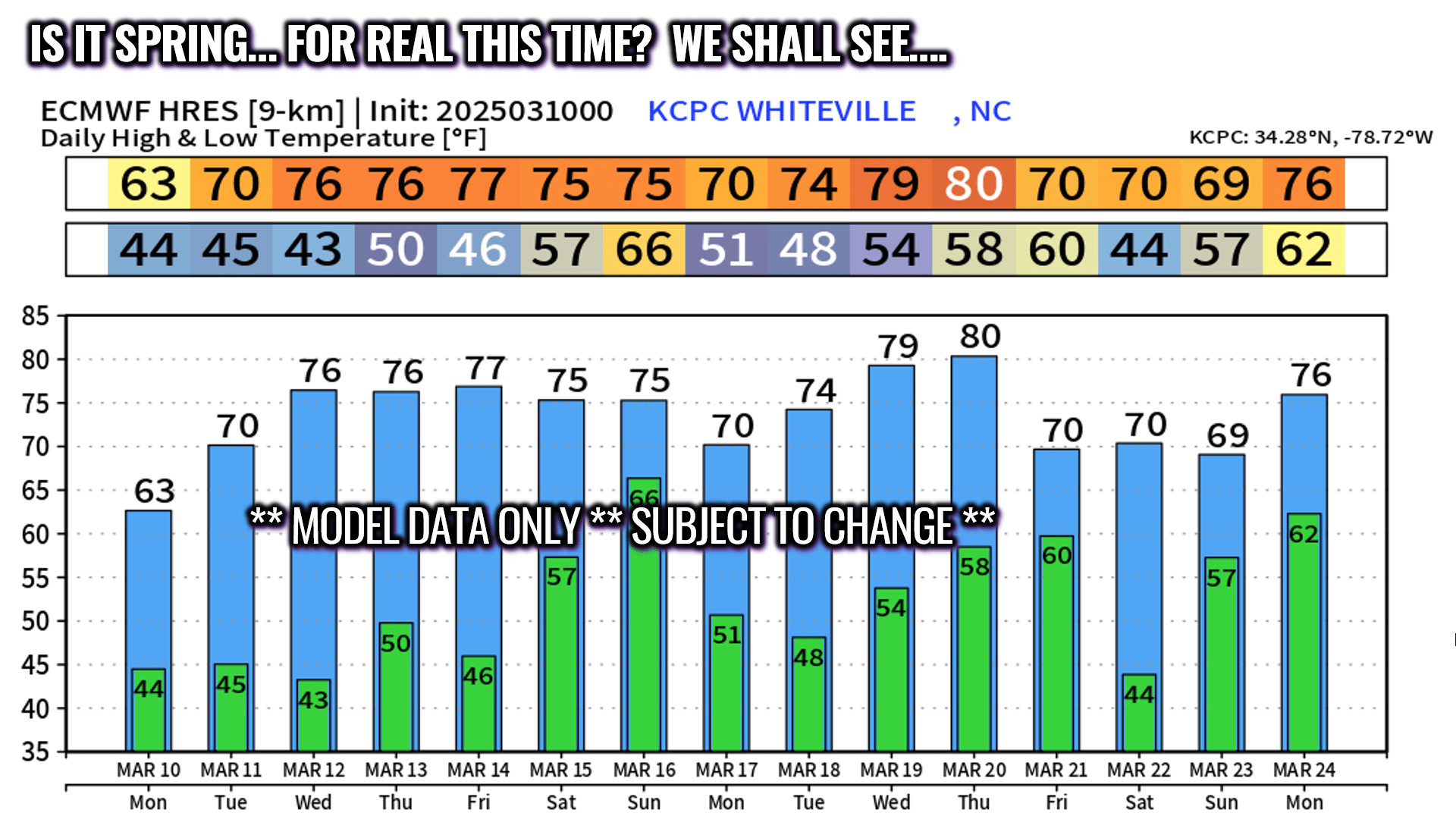
Looking at longer-term temperatures, neither the GFS nor European ensembles indicate any outbreaks of significant cold / sub-freezing temps through at least March 24th. That doesn’t mean things won’t change, but as of this writing, the lowest number found on the 82 various ensemble points is a “35.” If you’re going to do any spring planting, do so with a bit of caution. Winter may indeed be over but that doesn’t mean that the frost potential has ended. The model guidance suggests that it has… but I’m not ready to declare that we’ve had our last frost for the season. (A couple of the GFS plots have us flirting with the 90-degree mark on or about the 21st-22nd … I’m looking at that with a whole lot of “yeaahhh that ain’t gonna happen.”) Per NWS climatology data, the average “last freeze” for Whiteville is around March 29th. That is based on 30 years of data.
Here’s a look at the latest European model guidance going longer-term… maybe it’s spring for real this time. Again, these are the averages of all 50 ensemble members.
Here’s your Freedom Insurance Today-Plus-5 forecast for Columbus County.
That’ll do it for today. I hope you all have a wonderful day, and as always, take care.
~Meteorologist Christopher Cawley