
CCN Weather Update for Monday December 1, 2025.
This weather update is sponsored by Freedom Insurance of Whiteville. You can trust Freedom Insurance to give you clear blue skies when it comes to home, car, boat, or whatever insurance you need. Let Freedom provide customized coverage to keep you and your family safe. Contact Freedom today at 910-640-2828!
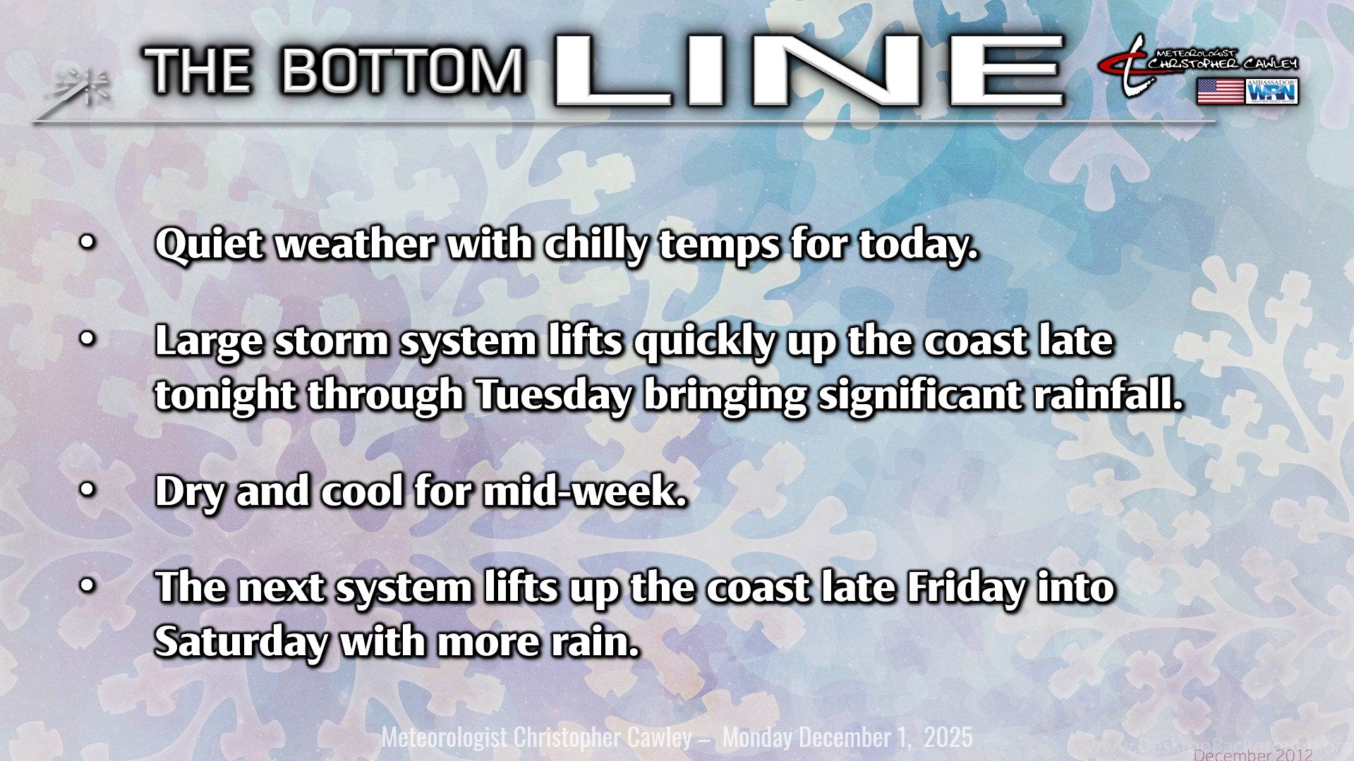
Here’s today’s Bottom Line
Welcome to Meteorological Winter! Hurricane Season is a thing of the past and now we talk about winter weather. You’ll read the expression “southern stream system” multiple times over the next 3-4 months.
Today will be rather calm and quiet thanks to a little wedge of high pressure over the area. A mix of sunshine and clouds will be the rule but I think we’ll trend mostly cloudy by the afternoon.
The cold front which moved through last night will hang up along the coast. This will provide a path for our next weather system, the first “southern stream system” of the winter season.
Low pressure will become organized and rapidly strengthen over southern Georgia late tonight. This system will move quickly up through the eastern Carolinas on Tuesday bringing widespread moderate to at-times heavy rainfall to the area.
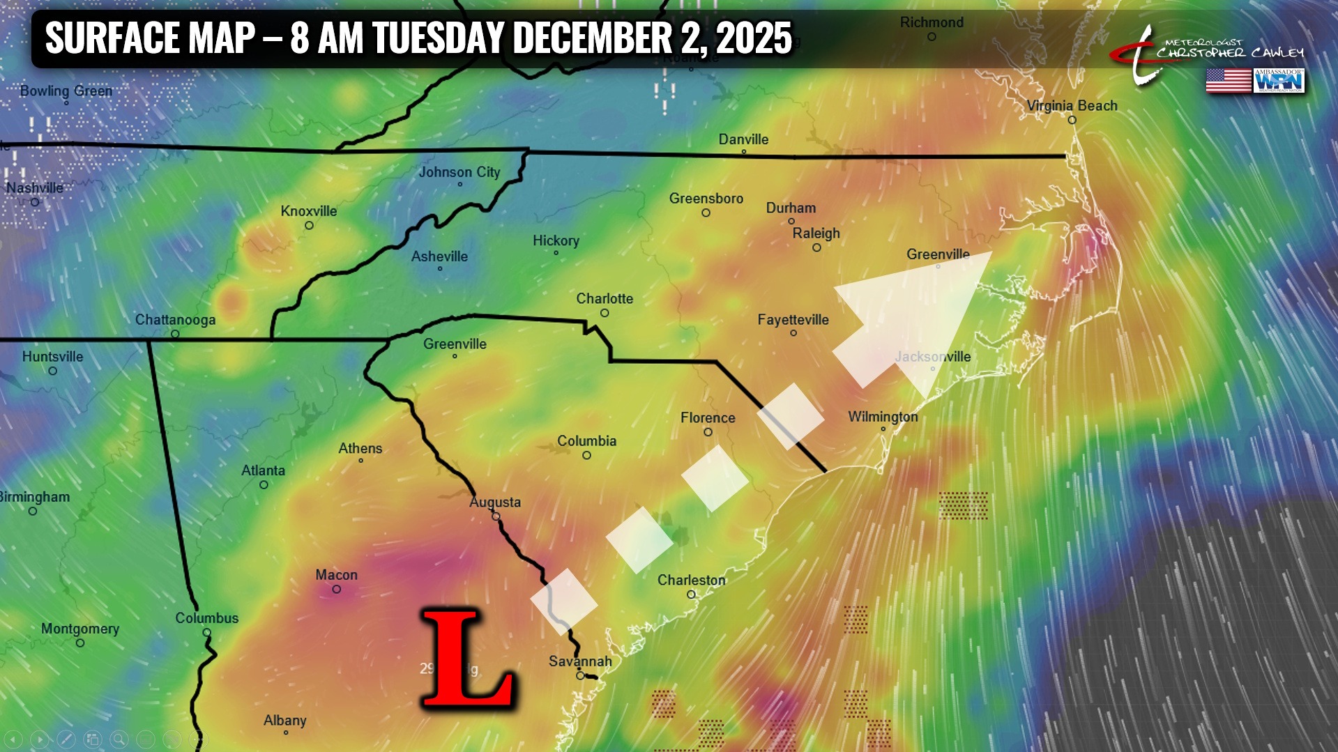
Along the coast, a warm front will try to push inland. The forward motion of the low should allow this front to perhaps cross into central Columbus County. This has a few implications on overall conditions for Tuesday.
First… temperatures. West of the front, temps will be stuck in the mid to upper 40s, while east of the front (closer to the coast), temperatures could rise into the lower 60s. I’m splitting the difference in my forecast, going with highs in the mid to upper 50s, but temperatures will likely fall into the 40s during the afternoon hours.
Second… thunderstorm potential. East of the front will exist modestly unstable air and a good deal of shear. There may be enough of both to lead to some isolated strong thunderstorms embedded within the rain, and these storms could produce an ISOLATED wind gust to 40-45 mph. I think this is a higher risk along the coast but some of that could push into the eastern half of Columbus County.
Another impact from this system is moderate to occasionally heavy rainfall. November was EXTREMELY dry for Whiteville… a grand total of 0.61″ rainfall for the month. The ongoing drought conditions should prevent any widespread/significant flooding; however, periods of heavy rain may bring nuisance flooding to low-lying and poor-drainage areas on Tuesday.

Rain will quickly end from southwest to northeast around or shortly after suppertime on Tuesday as a cold front sweeps across the area. HOWEVER… there may be enough lingering moisture that a few snowflakes fly at the tail end of the event during the early evening Tuesday.
Temperatures are likely to drop below freezing early Wednesday, so there may be some patchy black ice to deal with first thing Wednesday morning.
High pressure then settles in with cooler-than-normal temps Wednesday through early Friday. Highs will be in the lower 50s with lows 30-35.
The next Southern Stream System starts to take shape for Friday into the weekend. The high pressure wedge will be locked in place, with cold air trapped at the surface. Meanwhile, warmer, moist air starts to lift northeastward along the coast Friday afternoon with light rain developing. Rain becomes steady and… probably rather heavy… Friday night into Saturday. There are still some uncertainties with the storm track, but I think we should stay safely above freezing through this event. This looks like it will be another significant (1-inch-plus) rain event for the area.
Here is your Freedom Insurance Today-plus-Five Forecast:

–Meteorologist Christopher Cawley