Greetings friends, here’s your Thursday CCN Weather Update! We are sponsored, as always, by our friends at Freedom Insurance in Whiteville. If you need a policy for that sweet new Ram truck, they’ve got you covered. If you need a policy for the home you’re planning to purchase, they’ve got you covered. Contact them today at 910-640-2828 or stop in, and the Freedom Insurance representatives will work with you to write the best policy for your needs.
STATISTICS FOR WHITEVILLE – Wednesday February 12, 2025.
High: 47.8°F at 4:16 PM (normal is 57)
Low: 38.0°F at 4:50 AM (normal is 33)
Precip: 0.01 in
View live, real-time weather data for Whiteville on my College Street Weather Station.
Here’s your Bottom Line for today…
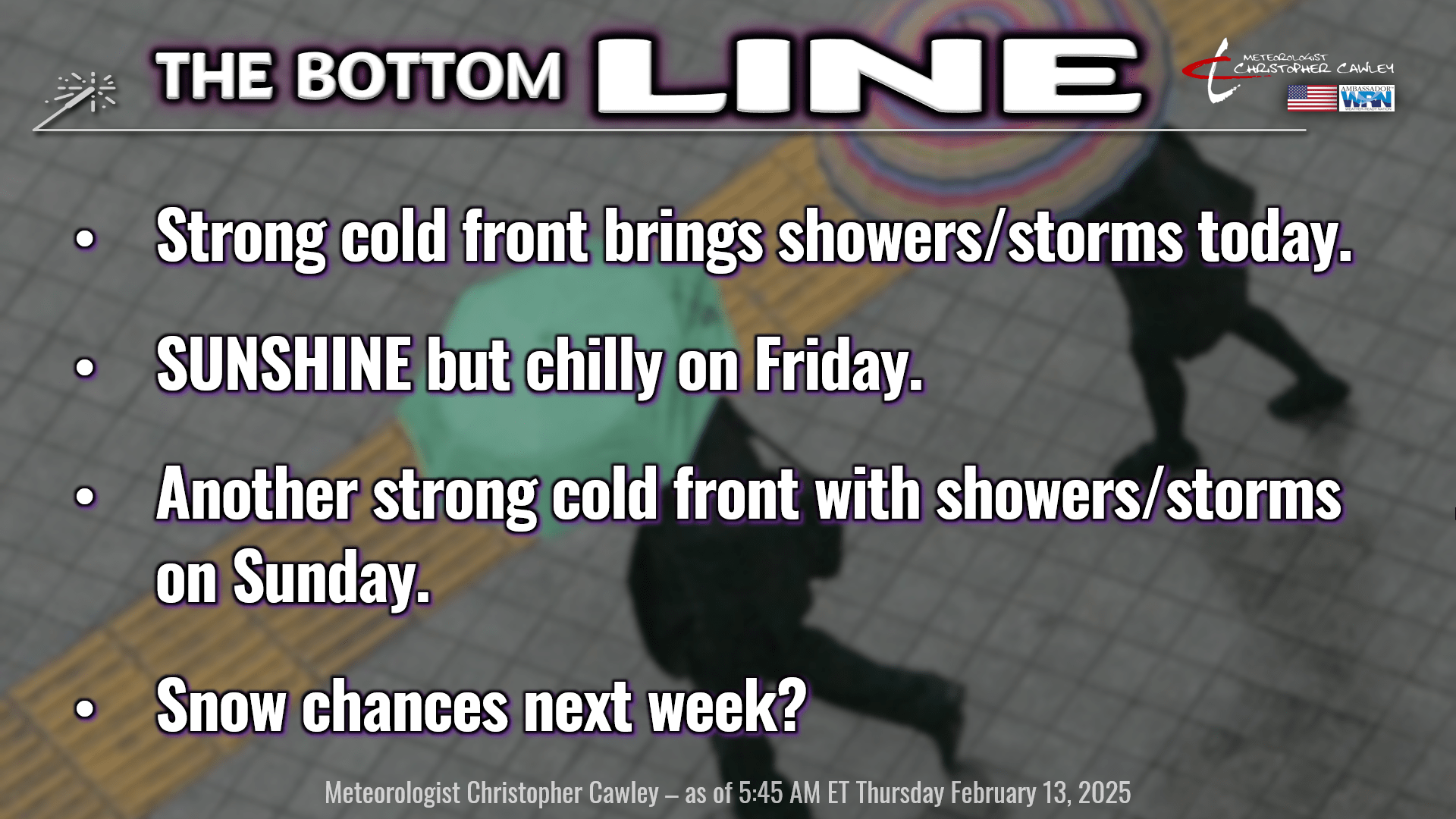
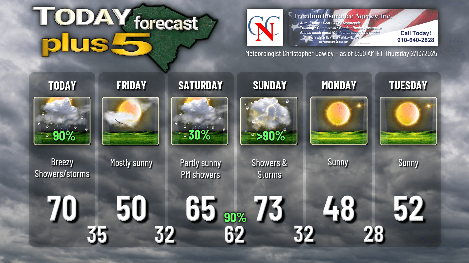
Today will be a fairly active weather day as a strong cold front will cross the area early this afternoon. Ahead of the front, a band of showers and thunderstorms is likely to move across the state.
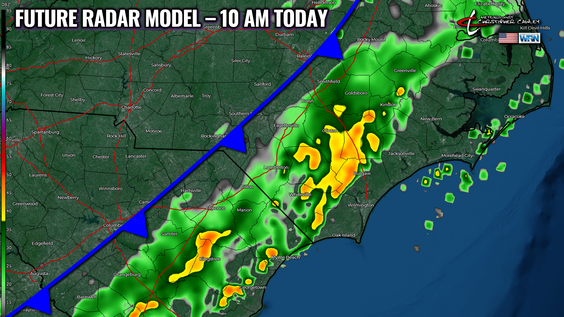
The extent of thunderstorm activity will depend on whether or not any bubbles of instability can form. With the early arrival of the rain band, I don’t expect a lot to occur… I believe we’ll see some gusty showers, with a bit of heavy rainfall, moving through just before lunchtime.
There may be some breaks of sunshine later this afternoon as colder and drier air starts to push in from the west/northwest. Our highs should peak around 70 by lunchtime, with temperatures falling through the 60s during the afternoon hours.
It’ll be a little bit breezy today, peak wind gusts in the 20-30 mph range can be expected.
Colder, dry air pushes in for real tonight. Our skies become clear and temps fall to the middle 30s. Some isolated spots may have some temperatures at or just below freezing at the bus stop Friday morning.
Yet another “wedge” (cold air damming) scenario develops on Friday. The difference with this one, when compared to the last few we’ve had over the past 2 weeks, is that moisture will be virtually nonexistent. Lots of sunshine for your Friday with temperatures running about 5-8 degrees below normal… highs around 50.
Partly cloudy skies on tap for Friday night. Temperatures should drop to about 30-33 across the area.
WEEKEND OUTLOOK.
Our weekend weather is going to be a virtual repeat of what we’re experiencing this morning and today.
Before I dive into the deets… I want to reference temps on Saturday. Saturday’s is a tricky forecast because that wedge is going to be difficult to break down (as always). This may be a case where the beaches are nice and warm but good ol’ ColCo stays a bit on the chilly side. I put 65 on the chart but that could change.
Anyway, a system developing on the southern jet stream will “phase” (merge) with one on the northern stream. A warm front lifts north over the area Saturday evening with rain. Temperatures hold steady or rise Saturday night. In the meantime, the main center of low pressure lifts through the Ohio Valley and to the east coast. This will drag a cold front across the area Sunday afternoon, with a vigorous southwesterly flow ahead of it. Atmospheric profiles show a strong low-level jet (at least 60 knots, which translates to about 70 mph), so we’ll have a breezy to possibly windy day on Sunday ahead of whatever convective line forms.
The timing is a little bit of a question right now, but ultimately I believe the front is off the coast by suppertime on Sunday. Showers and thunderstorms are almost certain to occur ahead of the front. We’re just a few hours too far out to have this picked up by the high-res modeling, but a blend of the GFS/ICON can give us a general picture of what we’re looking at on Sunday.
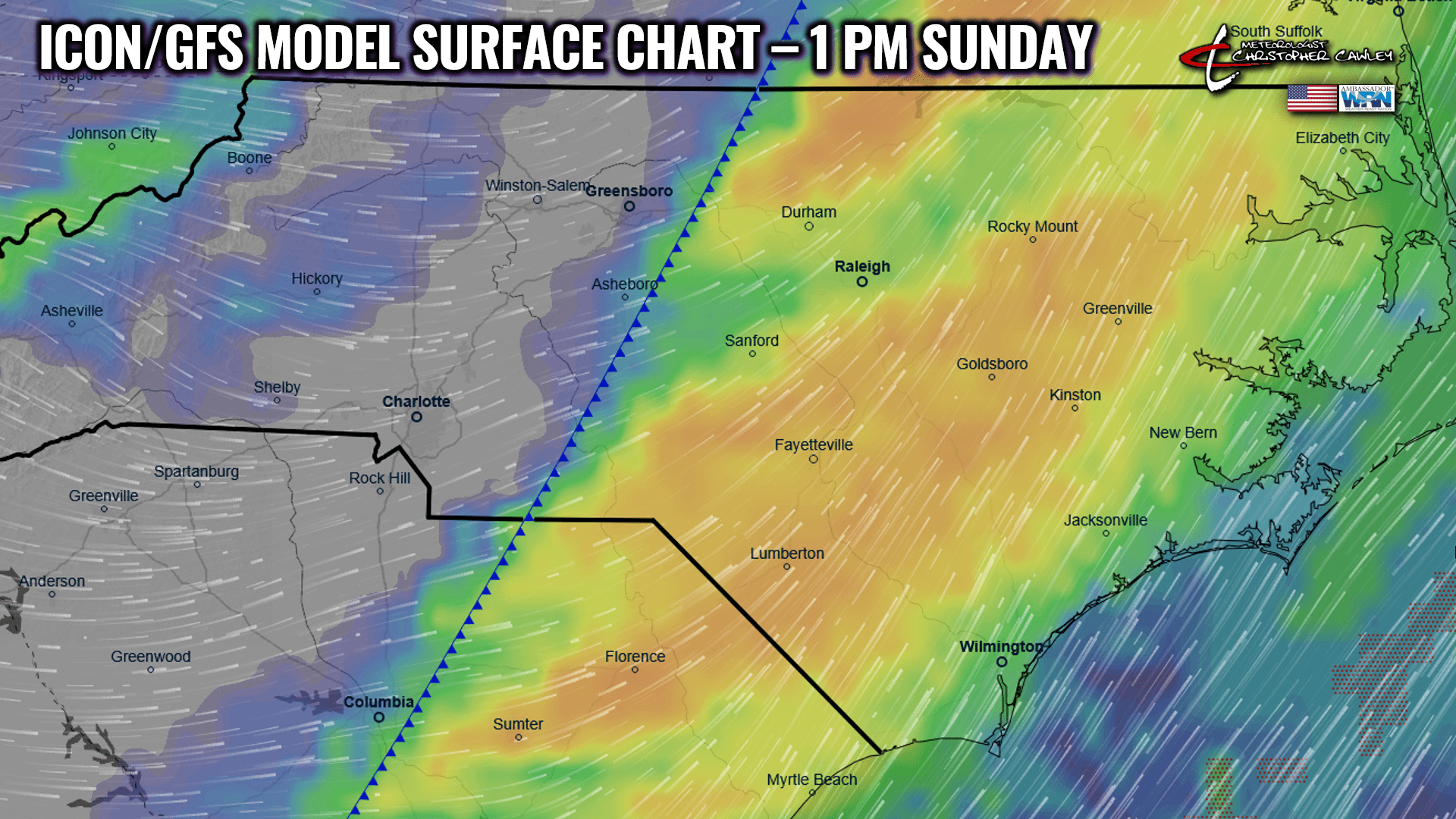
Severe weather threat is low. The guidance suggests that the strongest force/lifting goes off to the north.
NEXT WEEK… RETURN OF SNOW CHANCES?
Cold high pressure settles in on Monday and Tuesday with dry, sunny weather and temps running below normal. Nighttime temps will drop well into the 20s Monday night/early Tuesday, and probably again Tuesday night/early Wednesday.
Then the next weather system takes aim at the east coast. Some of you noticed the post I made on social media showing that the NWS has put nearly all of North Carolina under a “slight risk” for heavy SNOW on Thursday February 20th. Why are they highlighting that?
GFS, Euro, and Canadian deterministic modeling all agree that a storm system organizes over the central plains on Wednesday, with low pressure(s) lifting northward over the Tennessee valley, to a position off the coast by early Friday. There are timing differences with this, but that’s the general overview. Regular readers know that I don’t put an awful lot of weight in deterministic modeling more than about 7 days out, so I turn to the ensembles.
Well, the ensembles are in general agreement that yes, a system is going to hit the east coast next week. Out of 82 model ensembles (GFS and Euro combined), I have a count of 19 illustrating accumulating snowfall here around the 20th. 19 of 82 comes out to about 23%, which fits in line with the 20% probability given by the NWS.
Like I said yesterday, we’re still in the “7 to 10 day” range, so it’s “watchful waiting.” Cold air, moisture, and low pressure location will be the determining factors. We threaded the needle perfectly back in January… will we do it twice in one season?
Here’s your Freedom Insurance Today-Plus-5 forecast for Columbus County.
That wraps up today’s report… thank you for reading! I hope you all have a fantastic day. Take care!
~Meteorologist Christopher Cawley